Kapowsin
Census-designated place in Pierce County, Washington
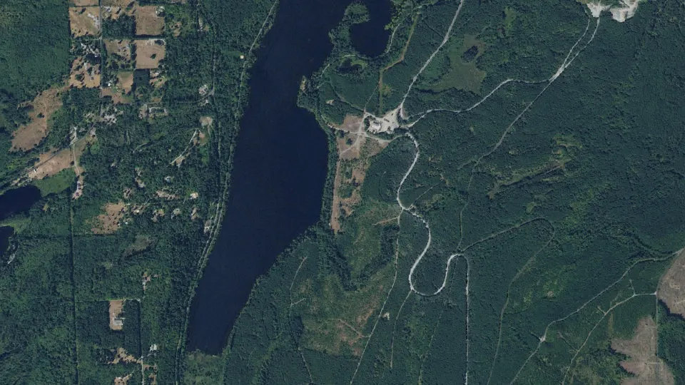
Kapowsin is an unincorporated community (census-designated place) in Pierce County, Washington, with 372 residents (2020 Census). It sits at 584 ft (178 m) above sea level. The nearest town is Clear Lake, 4.8 miles SW.
- 372residents (2020 Census)
- 584 ftelevation · 178 m
- 4.1 sq miland area · 10.7 km²
- 90 / sq mipopulation density
- 98338ZIP code
About Kapowsin
Kapowsin is a census-designated place located approximately 25 miles (38 kilometers) southeast of Tacoma in Pierce County, Washington, United States. The 2020 Census placed the population at 372.
Kapowsin, originally Kapousen Precinct, was named for its shallow lake. The ancient glacial drainage channel provides a nearly level connection between the
Puyallup and Nisqually Rivers, and formed a natural travel route at the base of the Cascade foothills. Chief Kapowsin was a fictional leader with an iron fist who lived on the lake's shores, a folklore told by the Nisqually tribe that lived in the nearby village of bacálabc (or bišál; southwest of Eatonville) prior to the area being settled in 1888.
Kapowsin was founded in 1901 when the Kapowsin Lumber Company built a sawmill at the community's present site. Located on the north end of Lake Kapowsin, the community was a thriving lumber town in the early part of the 20th century, with a high school, shops, and trades, and a population of about 10,000. After a decline in the timber industry, the town diminished in size into a neighborhood center, with a store, tavern, post office (US ZIP code 98344), fire station and grange hall. Kapowsin High School was abandoned in 1949 after being damaged in an earthquake. The 2010 Census placed the population at 333.
Kapowsin is located partially in the Bethel School District and partially in the Eatonville School District, and Kapowsin Elementary School is located nearby. Secondary students attend Frontier Junior High and Graham-Kapowsin High School, which opened in 2005. Tacoma Rail's freight line to Morton, Washington, runs through the town.
Text: Wikipedia · CC BY-SA 4.0
Kapowsin weather: 7-day forecast
Loading the National Weather Service forecast…
Source: National Weather Service (NOAA).
Live webcams in Kapowsin
Webcams: Windy.com
Living in Kapowsin
- Median home value
- $443,900
- Median age
- 39.9
Do you know Kapowsin? Tell us about it
Help other travelers: share what makes Kapowsin special. We review every message before publishing it.
Map of Kapowsin
Tap any street on the map to see it in Street View below. Map: © OpenStreetMap contributors.
Kapowsin Street View
Drag the image to look around and tap the arrows on the ground to move. If it says there is no imagery, tap a nearby street on the map above.
Open in Google Maps ›Kapowsin, WA population
Kapowsin had 372 residents in the 2020 Census.
| 2020 Census | 372 |
|---|---|
| Density | 90 per sq mi (35 per km²) |
Source: U.S. Census Bureau, Decennial Census.
Kapowsin at a glance
| State | Washington (WA) |
|---|---|
| County | Pierce County |
| Type | Census-designated place |
| Population | 372 (2020) |
| Land area | 4.12 sq mi (10.7 km²) |
| Water area | 1.01 sq mi (2.62 km²) |
| Elevation | 584 ft (178 m) |
| Coordinates | 46.9684° N, 122.2230° W |
| ZIP code | 98338 |
| Census code (GEOID) | 5334890 |
Sources: U.S. Census Bureau (Gazetteer, ZCTA), USGS GNIS, Wikidata.
Towns near Kapowsin
- Clear Lake4.8 mi SW
- Graham5.2 mi NW
- Eatonville7.3 mi S
- South Creek8.2 mi W
- Elk Plain8.4 mi NW
- Orting8.9 mi N
- Crocker9.6 mi NE
- Tehaleh10.4 mi N
- Frederickson10.7 mi NW
- McMillin10.9 mi N
- South Hill10.9 mi N
- La Grande11.3 mi S
Straight-line distance between town centers.
Frequently asked questions about Kapowsin
What county is Kapowsin in?
Kapowsin is in Pierce County, Washington.
What is the population of Kapowsin, WA?
372 people lived in Kapowsin at the 2020 Census.
What is the ZIP code of Kapowsin, WA?
The ZIP code of Kapowsin is 98338.
What is the elevation of Kapowsin?
584 feet (178 m) above sea level.
What towns are near Kapowsin?
Clear Lake (4.8 mi), Graham (5.2 mi), Eatonville (7.3 mi), South Creek (8.2 mi), Elk Plain (8.4 mi).
Last updated: