Umapine
Census-designated place in Umatilla County, Oregon
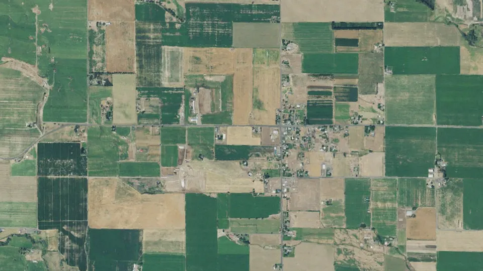
Umapine is an unincorporated community (census-designated place) in Umatilla County, Oregon, with 285 residents (2020 Census). It sits at 669 ft (204 m) above sea level. The nearest town is Milton-Freewater, 6.0 miles SE.
- 285residents (2020 Census)
- 669 ftelevation · 204 m
- 3.3 sq miland area · 8.6 km²
- 86 / sq mipopulation density
- 99324ZIP code
About Umapine
Umapine (/uməpaɪn/) is a census-designated place and unincorporated community in Umatilla County, Oregon, United States, two miles from the Oregon-Washington border. The traditional boundary covers a wide area. As of the 2020 census, Umapine had a population of 285. The community is part of the Pendleton–Hermiston Micropolitan Statistical Area. The current economy is supported by agriculture, including wheat and hay farms, apple orchards, and an increasing number of vineyards. The main establishments in the town are Tate's Umapine Market, The Umapine Creamery and the Waterhole Tavern.
For several decades the town had a school that served kindergarten through twelfth grade and whose mascot was the Umapine Chiefs. The enrollment at the school averaged 100 students. The school closed and incorporated with nearby Ferndale School District in 1984, which later incorporated with Milton-Freewater Unified School District in the early 1990s. In the early 1990s, the 1911 school building was sold to a local artist who established a fine art bronze foundry, Old School Bronze (formerly Northwest Art Casting). After the death of the owner, the school subsequently fell into disuse and placed on the market for sale. It is a three-story brick structure on 5 acres.
It is home to two restaurants, Tate's Mercantile and the Waterhole, and the Umapine Creamery. Tate's is housed in one of the original post office and creamery's from 1900s. The Waterhole has existed in various forms to the 1940s. Umapine Creamery is a newer addition. The family-run business and dairy sells cheese at premiere locations throughout the Walla Walla Valley. The tall, dark blue, water tower is a landmark among local pilots.
The community holds regular community "Spring Cleans" and Community Yard Sales. Alternating between the two every two years. The community is now home to several artisans as well as century-old cattle operations. The population is a mix of White and Hispanics. The town of 300 is home to several employers.
Text: Wikipedia · CC BY-SA 4.0
Umapine weather: 7-day forecast
Loading the National Weather Service forecast…
Source: National Weather Service (NOAA).
Live webcams in Umapine
Webcams: Windy.com
Living in Umapine
- Median household income
- $55,927
- Median home value
- $459,000
- Median rent
- $967/mo
- Median age
- 24.6
Do you know Umapine? Tell us about it
Help other travelers: share what makes Umapine special. We review every message before publishing it.
Map of Umapine
Tap any street on the map to see it in Street View below. Map: © OpenStreetMap contributors.
Umapine Street View
Drag the image to look around and tap the arrows on the ground to move. If it says there is no imagery, tap a nearby street on the map above.
Open in Google Maps ›Umapine, OR population
Umapine had 285 residents in the 2020 Census.
| 2020 Census | 285 |
|---|---|
| Density | 86 per sq mi (33 per km²) |
Source: U.S. Census Bureau, Decennial Census.
Umapine at a glance
| State | Oregon (OR) |
|---|---|
| County | Umatilla County |
| Type | Census-designated place |
| Population | 285 (2020) |
| Land area | 3.32 sq mi (8.6 km²) |
| Elevation | 669 ft (204 m) |
| Coordinates | 45.9759° N, 118.5009° W |
| ZIP code | 99324 |
| Census code (GEOID) | 4175600 |
Sources: U.S. Census Bureau (Gazetteer, ZCTA), USGS GNIS, Wikidata.
Towns near Umapine
- Milton-Freewater6.0 mi SE
- College Place, WA6.9 mi NE
- Garrett, WA7.1 mi NE
- Touchet, WA9.4 mi NW
- Walla Walla, WA10.1 mi NE
- Walla Walla East, WA10.7 mi NE
- Athena11.2 mi S
- Helix11.5 mi SW
- Weston11.7 mi S
- Adams14.8 mi S
- Dixie, WA20.2 mi NE
- Wallula, WA20.8 mi W
Straight-line distance between town centers.
Frequently asked questions about Umapine
What county is Umapine in?
Umapine is in Umatilla County, Oregon.
What is the population of Umapine, OR?
285 people lived in Umapine at the 2020 Census.
What is the ZIP code of Umapine, OR?
The ZIP code of Umapine is 99324.
What is the elevation of Umapine?
669 feet (204 m) above sea level.
What towns are near Umapine?
Milton-Freewater (6.0 mi), College Place (6.9 mi), Garrett (7.1 mi), Touchet (9.4 mi), Walla Walla (10.1 mi).
Last updated: