Valley
Census-designated place in Stevens County, Washington
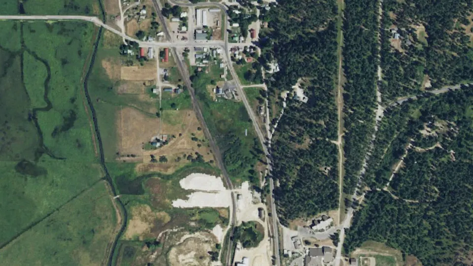
Valley is an unincorporated community (census-designated place) in Stevens County, Washington, with 149 residents (2020 Census). It sits at 1,696 ft (517 m) above sea level. The nearest town is Chewelah, 7.6 miles N.
- 149residents (2020 Census)
- 1,696 ftelevation · 517 m
- 0.4 sq miland area · 1.1 km²
- 348 / sq mipopulation density
- 99181ZIP code
About Valley
Valley is a census-designated place and unincorporated community in Stevens County, Washington, United States. As of the 2020 census, Valley had a population of 149.
The town of Valley was named by Daniel C. Corbin. Mr. Corbin named the town Valley, because it is at the entrance to the Colville Valley. The Spokane Falls and Northern Railway was connected to Valley in 1889. D. C.Corbin set up a small building for a depot.
Most inhabitants of the area were across the valley to the west of the river near the Fort Walla Walla Fort Colville Military Road. Few came to the east side, where current Valley is located, due to the swampy areas around the river. The oldest home in Valley was built in 1885 by the Jarvis family. John C. Jarvis was the first postmaster of Valley from December 1889 to November 1893.
George Kulzer came to Valley in 1889 and built a store, Kulzer and Son. In 1908, fire destroyed the store, saloon, and livery stable. The store was rebuilt and continues to stand today. George Kulzer built a corduroy road across the valley towards Waitts Lake.
Valley was first platted 29 July 1891. In the early days, Valley had its own bank, electric generator plant, phone company, water company and feed mill, two hotels, a drug store and blacksmith shop.
Valley is located on Washington State Route 231 8.5 miles (13.7 km) north of Springdale. Valley has a post office with ZIP code 99181.
Valley has an annual fair, the second Saturday of August. The emphasis is on creating an "old fashioned family atmosphere," and encouraging children and youth to learn and practice traditional craft, baking, and preservation skills.
Text: Wikipedia · CC BY-SA 4.0
Valley weather: 7-day forecast
Loading the National Weather Service forecast…
Source: National Weather Service (NOAA).
Live webcams in Valley
Webcams: Windy.com
Living in Valley
- Median home value
- $164,400
- Median age
- 63.8
Do you know Valley? Tell us about it
Help other travelers: share what makes Valley special. We review every message before publishing it.
Map of Valley
Tap any street on the map to see it in Street View below. Map: © OpenStreetMap contributors.
Valley Street View
Drag the image to look around and tap the arrows on the ground to move. If it says there is no imagery, tap a nearby street on the map above.
Open in Google Maps ›Valley, WA population
Valley had 149 residents in the 2020 Census.
| 2020 Census | 149 |
|---|---|
| Density | 348 per sq mi (134 per km²) |
Source: U.S. Census Bureau, Decennial Census.
Valley at a glance
| State | Washington (WA) |
|---|---|
| County | Stevens County |
| Type | Census-designated place |
| Population | 149 (2020) |
| Land area | 0.43 sq mi (1.1 km²) |
| Elevation | 1,696 ft (517 m) |
| Coordinates | 48.1729° N, 117.7245° W |
| ZIP code | 99181 |
| Census code (GEOID) | 5373885 |
Sources: U.S. Census Bureau (Gazetteer, ZCTA), USGS GNIS, Wikidata.
Towns near Valley
- Chewelah7.6 mi N
- Springdale8.1 mi S
- Loon Lake8.4 mi SE
- Addy13.9 mi N
- Clayton14.1 mi SE
- Deer Park19.5 mi SE
- Cusick22.6 mi NE
- Suncrest24.0 mi S
- Colville27.0 mi N
- Inchelium27.4 mi NW
- Twin Lakes29.9 mi W
- Newport30.9 mi E
Straight-line distance between town centers.
Frequently asked questions about Valley
What county is Valley in?
Valley is in Stevens County, Washington.
What is the population of Valley, WA?
149 people lived in Valley at the 2020 Census.
What is the ZIP code of Valley, WA?
The ZIP code of Valley is 99181.
What is the elevation of Valley?
1,696 feet (517 m) above sea level.
What towns are near Valley?
Chewelah (7.6 mi), Springdale (8.1 mi), Loon Lake (8.4 mi), Addy (13.9 mi), Clayton (14.1 mi).
Last updated: