Brownsville
City in Cameron County, Texas
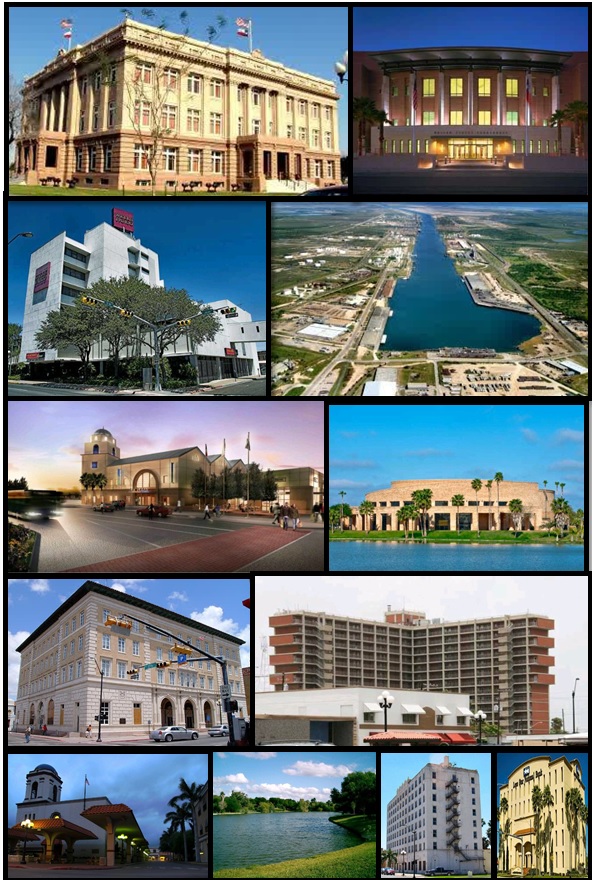
Brownsville is a city in Cameron County, Texas, with 186,738 residents (2020 Census). It sits at 33 ft (10 m) above sea level. The nearest town is Cameron Park, 1.3 miles S.
- 186,738residents (2020 Census)
- 33 ftelevation · 10 m
- 122.1 sq miland area · 316.2 km²
- 1,530 / sq mipopulation density
- 78526main ZIP code (3 in total)
About Brownsville
Brownsville is a city in the U.S. state of Texas and the largest city and county seat of Cameron County, located on the western Gulf Coast in South Texas, adjacent to the border with Matamoros, Tamaulipas, Mexico. The city covers 145.2 sq mi (376.066 km2), and had a population of 186,738 at the 2020 census. As of the 2020 U.S. census, it is the 136th-most populous city in the United States and 18th-most populous in Texas. It is part of the Matamoros–Brownsville metropolitan area. The city is known for its year-round subtropical climate, deep-water seaport, and Hispanic culture.
The city was founded in 1848 by American entrepreneur Charles Stillman after he developed a successful river-boat company nearby. It was named for Fort Brown, itself named after Major Jacob Brown, who fought and died while serving as a U.S. Army officer during the Mexican–American War (1846–1848). As a county seat, the city and county governments are major employers. Other primary employers fall within the service, trade, and manufacturing industries, including a growing aerospace and space transportation sector. It operates international trading through the Port of Brownsville. The city experienced a population increase in the early 1900s, when steel production flourished.
Due to significant historical events, the city has multiple houses and battle sites listed under the National Register of Historic Places. The city played a primary role in the Mexican–American War with the siege of Fort Texas and the first engagements of the war: The Battle of Palo Alto and the Battle of Resaca de la Palma. Several key events of the American Civil War took place in the city, such as the Battle of Brownsville and the Battle of Palmito Ranch. The city was also involved in the Texas Revolution. Brownsville's idiosyncratic geographic location has made it a wildlife refuge center. Several state parks and historical sites are protected by the Texas Parks and Wildlife Department.
Brownsville has a predominantly Hispanic population, which at 93.9% is the fourth-highest proportion of Hispanic Americans of any city in the United States outside of Puerto Rico.
Text: Wikipedia · CC BY-SA 4.0
Brownsville weather: 7-day forecast
Loading the National Weather Service forecast…
Source: National Weather Service (NOAA).
Live webcams in Brownsville
Webcams: Windy.com
Living in Brownsville
- Median household income
- $52,130
- Median home value
- $139,900
- Median rent
- $923/mo
- Median age
- 31.2
Do you know Brownsville? Tell us about it
Help other travelers: share what makes Brownsville special. We review every message before publishing it.
Map of Brownsville
Tap any street on the map to see it in Street View below. Map: © OpenStreetMap contributors.
Brownsville Street View
Drag the image to look around and tap the arrows on the ground to move. If it says there is no imagery, tap a nearby street on the map above.
Open in Google Maps ›Brownsville, TX population
Brownsville had 186,738 residents in the 2020 Census.
| 2020 Census | 186,738 |
|---|---|
| Density | 1,530 per sq mi (591 per km²) |
Source: U.S. Census Bureau, Decennial Census.
Brownsville at a glance
| State | Texas (TX) |
|---|---|
| County | Cameron County |
| Type | City |
| Population | 186,738 (2020) |
| Land area | 122.08 sq mi (316.2 km²) |
| Water area | 6.42 sq mi (16.63 km²) |
| Elevation | 33 ft (10 m) |
| Coordinates | 25.9894° N, 97.4806° W |
| ZIP codes | 78526, 78520, 78575 |
| Official website | cob.us |
| Census code (GEOID) | 4810768 |
Sources: U.S. Census Bureau (Gazetteer, ZCTA), USGS GNIS, Wikidata.
Towns near Brownsville
- Cameron Park1.3 mi S
- Olmito4.5 mi NW
- Rancho Viejo5.6 mi NW
- Del Mar Heights5.8 mi NE
- Los Fresnos5.9 mi N
- Reid Hope King6.2 mi SE
- Orason6.2 mi N
- Chula Vista6.4 mi NE
- San Pedro6.7 mi W
- Indian Lake6.9 mi N
- Villa Pancho8.3 mi SE
- Laureles9.0 mi N
Straight-line distance between town centers.
Frequently asked questions about Brownsville
What county is Brownsville in?
Brownsville is in Cameron County, Texas.
What is the population of Brownsville, TX?
186,738 people lived in Brownsville at the 2020 Census.
What is the ZIP code of Brownsville, TX?
The main ZIP code is 78526. Other ZIP codes: 78520, 78575.
What is the elevation of Brownsville?
33 feet (10 m) above sea level.
What towns are near Brownsville?
Cameron Park (1.3 mi), Olmito (4.5 mi), Rancho Viejo (5.6 mi), Del Mar Heights (5.8 mi), Los Fresnos (5.9 mi).
Last updated: