Greenville
City in Greenville County, South Carolina
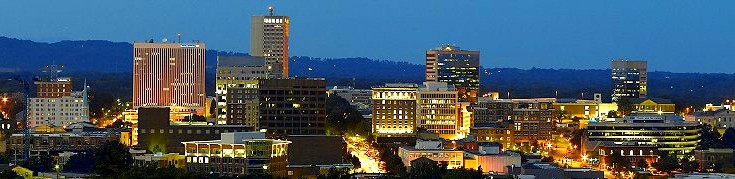
Greenville is a city in Greenville County, South Carolina, with 70,720 residents (2020 Census). It sits at 965 ft (294 m) above sea level. The nearest town is Dunean, 3.6 miles W.
- 70,720residents (2020 Census)
- 965 ftelevation · 294 m
- 30.9 sq miland area · 80.0 km²
- 2,290 / sq mipopulation density
- 29601main ZIP code (4 in total)
About Greenville
Greenville ( GREEN-vil, locally GREEN-vəl) is a city in Greenville County, South Carolina, United States, and its county seat. It is the sixth-most populous city in South Carolina, with a population of 70,720 at the 2020 census, while the Greenville metropolitan area has an estimated 1 million residents and is the largest metropolitan area in the state.
Greenville is located approximately halfway between Atlanta and Charlotte along I-85; its metro area also includes I-185 and I-385. It is the anchor city of Upstate South Carolina, an economic and cultural region in the foothills of the Blue Ridge Mountains with an estimated population of 1.63 million.
Greenville was established in 1797 and incorporated in 1831. The city experienced early growth through the development of cotton mills and rail infrastructure, which positioned it as a key industrial hub in the Southeast. In recent decades, Greenville has shifted toward advanced manufacturing and automotive production. Numerous companies have offices within the city, such as Michelin, Prisma Health, Bon Secours, and Duke Energy. Its cultural institutions include the Peace Center and Greenville County Museum of Art, as well as the Falls Park on the Reedy next to Downtown Greenville.
Text: Wikipedia · CC BY-SA 4.0
Greenville weather: 7-day forecast
Loading the National Weather Service forecast…
Source: National Weather Service (NOAA).
Live webcams in Greenville
Webcams: Windy.com
Living in Greenville
- Median household income
- $71,472
- Median home value
- $487,500
- Median rent
- $1,312/mo
- Median age
- 34.7
Do you know Greenville? Tell us about it
Help other travelers: share what makes Greenville special. We review every message before publishing it.
Map of Greenville
Tap any street on the map to see it in Street View below. Map: © OpenStreetMap contributors.
Greenville Street View
Drag the image to look around and tap the arrows on the ground to move. If it says there is no imagery, tap a nearby street on the map above.
Open in Google Maps ›Greenville, SC population
Greenville had 70,720 residents in the 2020 Census.
| 2020 Census | 70,720 |
|---|---|
| Density | 2,290 per sq mi (884 per km²) |
Source: U.S. Census Bureau, Decennial Census.
Greenville at a glance
| State | South Carolina (SC) |
|---|---|
| County | Greenville County |
| Type | City |
| Population | 70,720 (2020) |
| Land area | 30.89 sq mi (80.0 km²) |
| Water area | 0.24 sq mi (0.62 km²) |
| Elevation | 965 ft (294 m) |
| Coordinates | 34.8369° N, 82.3630° W |
| ZIP codes | 29601, 29607, 29614, 29615 |
| Official website | greenvillesc.gov |
| Census code (GEOID) | 4530850 |
Sources: U.S. Census Bureau (Gazetteer, ZCTA), USGS GNIS, Wikidata.
Towns near Greenville
- Dunean3.6 mi W
- Wade Hampton3.6 mi NE
- Judson3.7 mi W
- City View4.0 mi NW
- Gantt4.4 mi SW
- Sans Souci5.0 mi NW
- Conestee5.1 mi S
- Mauldin5.1 mi SE
- Parker5.2 mi W
- Taylors6.0 mi NE
- Welcome6.4 mi W
- Berea6.5 mi NW
Straight-line distance between town centers.
Frequently asked questions about Greenville
What county is Greenville in?
Greenville is in Greenville County, South Carolina.
What is the population of Greenville, SC?
70,720 people lived in Greenville at the 2020 Census.
What is the ZIP code of Greenville, SC?
The main ZIP code is 29601. Other ZIP codes: 29607, 29614, 29615.
What is the elevation of Greenville?
965 feet (294 m) above sea level.
What towns are near Greenville?
Dunean (3.6 mi), Wade Hampton (3.6 mi), Judson (3.7 mi), City View (4.0 mi), Gantt (4.4 mi).
Last updated: