University of Pittsburgh Bradford
Census-designated place in McKean County, Pennsylvania
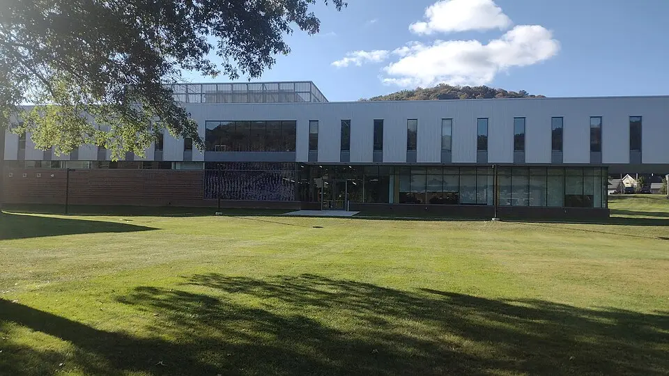
University of Pittsburgh Bradford is an unincorporated community (census-designated place) in McKean County, Pennsylvania, with 920 residents (2020 Census). The nearest town is Bradford, 2.0 miles NE.
- 920residents (2020 Census)
- 0.1 sq miland area · 0.3 km²
- 8,510 / sq mipopulation density
- 16725ZIP code
About University of Pittsburgh Bradford
The University of Pittsburgh at Bradford (Pitt-Bradford or UPB) is a state-related college in Bradford Township, McKean County, Pennsylvania. Founded in 1963, it is a baccalaureate degree-granting, regional campus of the University of Pittsburgh, conferring degrees in over 40 fields of study. In addition to its focus on undergraduate education, the campus hosts multiple research/teaching units of the University of Pittsburgh, including the Center for Rural Health Practice and the Allegheny Institute of Natural History, as well as the Marilyn Horne Museum and Exhibit Center.
Pitt-Bradford is a residential college and most students reside in one of sixteen on-campus residence halls. UPB athletic programs are affiliated with NCAA Division III, competing as members of the Allegheny Mountain Collegiate Conference.
Text: Wikipedia · CC BY-SA 4.0
University of Pittsburgh Bradford weather: 7-day forecast
Loading the National Weather Service forecast…
Source: National Weather Service (NOAA).
Live webcams in University of Pittsburgh Bradford
Webcams: Windy.com
Things to do in University of Pittsburgh Bradford
Top places to visit in and around University of Pittsburgh Bradford: Allegany State Park, Kinzua Bridge State Park and Bradford Downtown Historic District.
 Allegany State ParkState park · 12 mi N
 Kinzua Bridge State ParkState park · 14 mi S
 Bradford Downtown Historic DistrictHistoric district · 1.4 mi NE
 Eldred World War II MuseumMuseum · 15 mi E
Museums & galleries (1)Historic sites & landmarks (6)Parks & gardens (2)Hiking trails (1)Scenic viewpoints & peaks (2)Nature reserves & natural wonders (2)Theaters & public art (1)
All 15 things to do in University of Pittsburgh Bradford ›Small communities near University of Pittsburgh Bradford
Schools near University of Pittsburgh Bradford
There are no public schools inside University of Pittsburgh Bradford. The nearest elementary school is School Street El Sch (1.4 mi NE); the nearest middle school is Floyd C Fretz MS (3.2 mi NE); the nearest high school is Bradford Area HS (1.3 mi NE).
| School | Grades | Students | Students per teacher | Type | Distance |
|---|---|---|---|---|---|
| Bradford Area HS Bradford · Bradford Area SD | 9–12 | 702 | 13.0 | Public | 1.3 mi NE |
| School Street El Sch Bradford · Bradford Area SD | 3–5 | 514 | 13.5 | Public | 1.4 mi NE |
| George Blaisdell El Sch Bradford · Bradford Area SD | PK–2 | 506 | 11.2 | Public | 2.5 mi NE |
| Floyd C Fretz MS Bradford · Bradford Area SD | 6–8 | 508 | 13.0 | Public | 3.2 mi NE |
| Otto-Eldred JSHS Duke Center · Otto-Eldred SD | 7–12 | 273 | 12.4 | Public | 10 mi E |
| ALLEGANY-LIMESTONE ELEMENTARY SCHOOL Allegany · ALLEGANY-LIMESTONE CENTRAL SCHOOL DISTRICT | PK–5 | 466 | 12.3 | Public | 14 mi NE |
Do you know University of Pittsburgh Bradford? Tell us about it
Help other travelers: share what makes University of Pittsburgh Bradford special. We review every message before publishing it.
Map of University of Pittsburgh Bradford
Tap any street on the map to see it in Street View below. Map: © OpenStreetMap contributors.
University of Pittsburgh Bradford Street View
Drag the image to look around and tap the arrows on the ground to move. If it says there is no imagery, tap a nearby street on the map above.
Open in Google Maps ›University of Pittsburgh Bradford, PA population
University of Pittsburgh Bradford had 920 residents in the 2020 Census.
| 2020 Census | 920 |
|---|---|
| Density | 8,510 per sq mi (3,286 per km²) |
Source: U.S. Census Bureau, Decennial Census.
University of Pittsburgh Bradford at a glance
| State | Pennsylvania (PA) |
|---|---|
| County | McKean County |
| Type | Census-designated place |
| Population | 920 (2020) |
| Land area | 0.11 sq mi (0.3 km²) |
| Coordinates | 41.9443° N, 78.6728° W |
| ZIP code | 16725 |
| Official website | upb.pitt.edu |
| Census code (GEOID) | 4278698 |
Sources: U.S. Census Bureau (Gazetteer, ZCTA), USGS GNIS, Wikidata.
Towns near University of Pittsburgh Bradford
- Bradford2.0 mi NE
- Foster3.1 mi NE
- Foster Brook4.5 mi NE
- Lewis Run5.4 mi S
- Limestone, NY5.5 mi N
- Rew7.6 mi SE
- Lafayette9.3 mi S
- Otto9.7 mi E
- Corydon9.9 mi W
- Keating11.9 mi SE
- Allegany, NY13.8 mi NE
- St. Bonaventure, NY13.8 mi NE
Straight-line distance between town centers.
Frequently asked questions about University of Pittsburgh Bradford
What county is University of Pittsburgh Bradford in?
University of Pittsburgh Bradford is in McKean County, Pennsylvania.
What is the population of University of Pittsburgh Bradford, PA?
920 people lived in University of Pittsburgh Bradford at the 2020 Census.
What is the ZIP code of University of Pittsburgh Bradford, PA?
The ZIP code of University of Pittsburgh Bradford is 16725.
What towns are near University of Pittsburgh Bradford?
Bradford (2.0 mi), Foster (3.1 mi), Foster Brook (4.5 mi), Lewis Run (5.4 mi), Limestone (5.5 mi).
Last updated: