Hammon
Town in Roger Mills County, Oklahoma
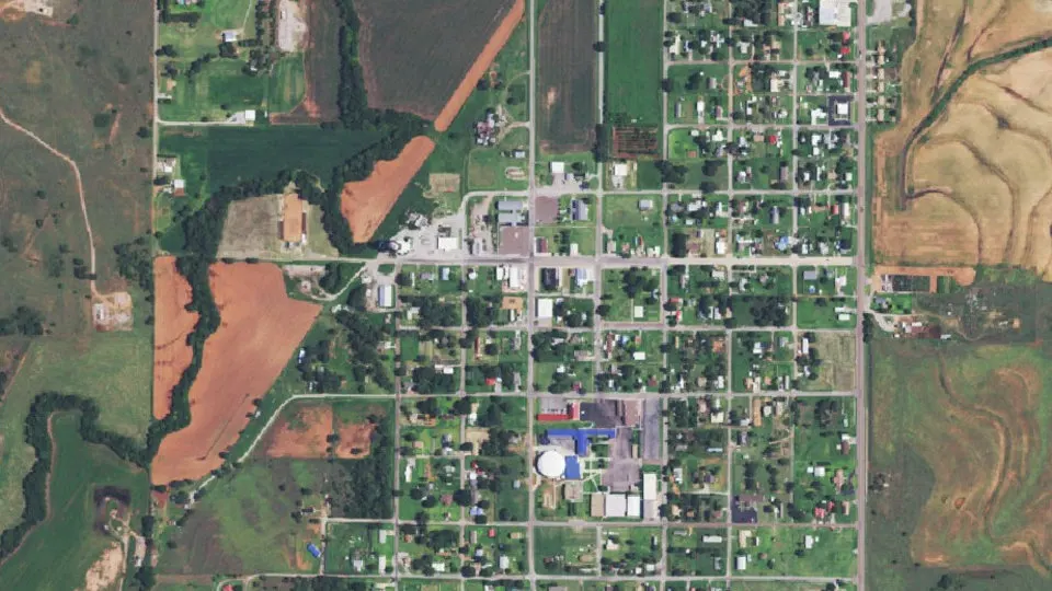
Hammon is a town in Roger Mills County, Oklahoma, with 479 residents (2020 Census). It sits at 1,745 ft (532 m) above sea level. The nearest town is Butler, 11.1 miles E.
- 479residents (2020 Census)
- 1,745 ftelevation · 532 m
- 0.7 sq miland area · 1.9 km²
- 654 / sq mipopulation density
- 73650ZIP code
About Hammon
Hammon (Arapaho: Hiisiis Be'eih) is a town in the U.S. state of Oklahoma, the majority of which is in Roger Mills County, but some of which extends into Custer County. It is located at the junction of Oklahoma State Highways 33 and 34.
The town is named for Indian agent James H. Hammon, who was assigned to the Red Moon Agency near the future site of Hammon. This was a subagency of the Cheyenne-Arapaho Agency at Darlington, north of Fort Reno, and his mission was to build a reservation school and to teach the Cheyenne and Arapaho to farm. His wife, Ida M. Hammon, was postmaster when a post office was established in their home on June 30, 1894.
The townsite was originally located in Custer County, but when the Wichita Falls and Northwestern Railroad (later known as the Missouri, Kansas and Texas Railway) laid track west of the town in 1910, the majority of the town was moved west into Roger Mills County to be near the railroad. On May 22, 1911, the board of county commissioners accepted the incorporation of the town.
The population was 479 at the time of the 2020 census.
Text: Wikipedia · CC BY-SA 4.0
Hammon weather: 7-day forecast
Loading the National Weather Service forecast…
Source: National Weather Service (NOAA).
Nearest webcams to Hammon
There are no webcams in Hammon itself. These are the closest, 46 miles away or more.
Webcams: Windy.com
Living in Hammon
- Median household income
- $52,500
- Median home value
- $83,800
- Median rent
- $775/mo
- Median age
- 34.3
Do you know Hammon? Tell us about it
Help other travelers: share what makes Hammon special. We review every message before publishing it.
Map of Hammon
Tap any street on the map to see it in Street View below. Map: © OpenStreetMap contributors.
Hammon Street View
Drag the image to look around and tap the arrows on the ground to move. If it says there is no imagery, tap a nearby street on the map above.
Open in Google Maps ›Hammon, OK population
Hammon had 479 residents in the 2020 Census.
| 2020 Census | 479 |
|---|---|
| Density | 654 per sq mi (253 per km²) |
Source: U.S. Census Bureau, Decennial Census.
Hammon at a glance
| State | Oklahoma (OK) |
|---|---|
| County | Roger Mills County |
| Type | Town |
| Population | 479 (2020) |
| Land area | 0.73 sq mi (1.9 km²) |
| Elevation | 1,745 ft (532 m) |
| Coordinates | 35.6323° N, 99.3832° W |
| ZIP code | 73650 |
| Census code (GEOID) | 4032250 |
Sources: U.S. Census Bureau (Gazetteer, ZCTA), USGS GNIS, Wikidata.
Towns near Hammon
- Butler11.1 mi E
- Strong City12.5 mi W
- Canute15.7 mi SE
- Leedey16.5 mi N
- Cheyenne16.5 mi W
- Elk City17.0 mi S
- Foss17.4 mi SE
- Burns Flat22.5 mi SE
- Arapaho24.1 mi E
- Clinton24.8 mi E
- Sayre27.0 mi SW
- Camargo27.2 mi N
Straight-line distance between town centers.
Frequently asked questions about Hammon
What county is Hammon in?
Hammon is in Roger Mills County, Oklahoma.
What is the population of Hammon, OK?
479 people lived in Hammon at the 2020 Census.
What is the ZIP code of Hammon, OK?
The ZIP code of Hammon is 73650.
What is the elevation of Hammon?
1,745 feet (532 m) above sea level.
What towns are near Hammon?
Butler (11.1 mi), Strong City (12.5 mi), Canute (15.7 mi), Leedey (16.5 mi), Cheyenne (16.5 mi).
Last updated: