Landen
Census-designated place in Warren County, Ohio
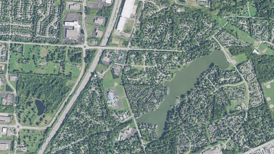
Landen is an unincorporated community (census-designated place) in Warren County, Ohio, with 6,995 residents (2020 Census). It sits at 814 ft (248 m) above sea level. The nearest town is Loveland Park, 1.9 miles SE.
- 6,995residents (2020 Census)
- 814 ftelevation · 248 m
- 2.0 sq miland area · 5.3 km²
- 3,450 / sq mipopulation density
- 45039ZIP code
About Landen
Landen is a middle-class, real estate developer-created census-designated place (CDP) in Deerfield Township, Warren County, Ohio, United States. The population was 6,995 at the 2020 census. It is located around Columbia Road and Montgomery Road in the southeastern part of the township. It surrounds Twenty Mile Stand, near Fosters.
Landen was named after Theodophilus James Landen, an early Ohio settler who owned the farmland surrounding Twenty Mile Stand. The man-made “Landen Lake,” formed by creating a dam along Simpson’s Creek to create a flood retention area, is located within the residential area in a housing development. The formal place designation is "Landen Farm Drainage Lake". It is not a natural lake.
The reduction in farming activity in the immediate area of the water has reduced its importance as a water supply, although flood control is still important. The “lake” was created for flood control and to enhance the surrounding land for housing development. This water feature is sometimes used for limited, slow pontoon boat recreation, although the one-mile length limits recreational options.
It is now best described as a retention basin. The retention basin was dredged for improved flood protection with the completion in 2008 of a dredging operation that removed 184,000 cubic yards of sediment from the lake.
Text: Wikipedia · CC BY-SA 4.0
Landen weather: 7-day forecast
Loading the National Weather Service forecast…
Source: National Weather Service (NOAA).
Live webcams in Landen
Webcams: Windy.com
Living in Landen
- Median household income
- $109,434
- Median home value
- $311,000
- Median rent
- $1,569/mo
- Median age
- 41.2
Do you know Landen? Tell us about it
Help other travelers: share what makes Landen special. We review every message before publishing it.
Map of Landen
Tap any street on the map to see it in Street View below. Map: © OpenStreetMap contributors.
Landen Street View
Drag the image to look around and tap the arrows on the ground to move. If it says there is no imagery, tap a nearby street on the map above.
Open in Google Maps ›Landen, OH population
Landen had 6,995 residents in the 2020 Census.
| 2020 Census | 6,995 |
|---|---|
| Density | 3,450 per sq mi (1,332 per km²) |
Source: U.S. Census Bureau, Decennial Census.
Landen at a glance
| State | Ohio (OH) |
|---|---|
| County | Warren County |
| Type | Census-designated place |
| Population | 6,995 (2020) |
| Land area | 2.03 sq mi (5.3 km²) |
| Water area | 0.09 sq mi (0.24 km²) |
| Elevation | 814 ft (248 m) |
| Coordinates | 39.3186° N, 84.2838° W |
| ZIP code | 45039 |
| Census code (GEOID) | 3941755 |
Sources: U.S. Census Bureau (Gazetteer, ZCTA), USGS GNIS, Wikidata.
Towns near Landen
- Loveland Park1.9 mi SE
- Mason3.0 mi N
- Kings Mills3.5 mi NE
- Loveland3.6 mi S
- Sixteen Mile Stand3.8 mi SW
- Highpoint4.0 mi SW
- Brecon4.6 mi SW
- South Lebanon4.6 mi NE
- Maineville5.3 mi E
- Montgomery5.8 mi SW
- Wetherington5.8 mi NW
- Four Bridges5.9 mi NW
Straight-line distance between town centers.
Frequently asked questions about Landen
What county is Landen in?
Landen is in Warren County, Ohio.
What is the population of Landen, OH?
6,995 people lived in Landen at the 2020 Census.
What is the ZIP code of Landen, OH?
The ZIP code of Landen is 45039.
What is the elevation of Landen?
814 feet (248 m) above sea level.
What towns are near Landen?
Loveland Park (1.9 mi), Mason (3.0 mi), Kings Mills (3.5 mi), Loveland (3.6 mi), Sixteen Mile Stand (3.8 mi).
Last updated: