Hall
Census-designated place in Ontario County, New York
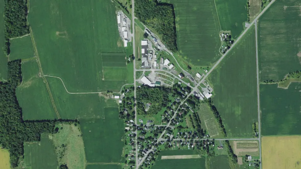
Hall is an unincorporated community (census-designated place) in Ontario County, New York, with 202 residents (2020 Census). It sits at 899 ft (274 m) above sea level. The nearest town is Gorham, 3.4 miles W.
- 202residents (2020 Census)
- 899 ftelevation · 274 m
- 1.0 sq miland area · 2.6 km²
- 198 / sq mipopulation density
- 14463ZIP code
About Hall
Hall is a hamlet and census-designated place in Ontario County, New York, United States, located along State Route 14A in the Town of Seneca, near the city of Geneva and the Town of Geneva.
Located in the Finger Lakes region, Hall has a fire department and a post office with a downtown zip code of 14463, though the urbanized area extends beyond this. Hall also has various agricultural enterprises, including a tractor retailer, a seed production company (Seedway), and a fertilizer company (Hall Fertilizer Corp.). Seedway, a subsidiary of Growmark, serves the entire Northeast and is headquartered in Hall.
As of the 2010 census, Hall has a population of 216. With the exception of one Korean, the population was fully non-Hispanic white. Of the 97 housing units in the hamlet, 12 were vacant and the median household income was $74,861, reflective of its relatively robust economy. None of the population was below the poverty line.
Hall and the surrounding area were settled and cleared, mostly as farmland, around the turn of the 19th century, with a wave of migration from England. The hamlet, which was originally established as Hall's Corners, was informally known as "the English settlement." Starting in the mid-19th century, Hall had a station on a since removed section of line of the now defunct Elmira Rail Road Company, a subsidiary of the Northern Central Railroad. Despite this, Hall has retained its status as an active agricultural center.
Text: Wikipedia · CC BY-SA 4.0
Hall weather: 7-day forecast
Loading the National Weather Service forecast…
Source: National Weather Service (NOAA).
Live webcams in Hall
Webcams: Windy.com
Living in Hall
- Median household income
- $46,250
- Median home value
- $157,900
- Median age
- 34.3
Do you know Hall? Tell us about it
Help other travelers: share what makes Hall special. We review every message before publishing it.
Map of Hall
Tap any street on the map to see it in Street View below. Map: © OpenStreetMap contributors.
Hall Street View
Drag the image to look around and tap the arrows on the ground to move. If it says there is no imagery, tap a nearby street on the map above.
Open in Google Maps ›Hall, NY population
Hall had 202 residents in the 2020 Census.
| 2020 Census | 202 |
|---|---|
| Density | 198 per sq mi (76 per km²) |
Source: U.S. Census Bureau, Decennial Census.
Hall at a glance
| State | New York (NY) |
|---|---|
| County | Ontario County |
| Type | Census-designated place |
| Population | 202 (2020) |
| Land area | 1.02 sq mi (2.6 km²) |
| Elevation | 899 ft (274 m) |
| Coordinates | 42.7965° N, 77.0680° W |
| ZIP code | 14463 |
| Census code (GEOID) | 3631533 |
Sources: U.S. Census Bureau (Gazetteer, ZCTA), USGS GNIS, Wikidata.
Towns near Hall
- Gorham3.4 mi W
- Geneva6.3 mi NE
- Rushville8.5 mi W
- Penn Yan9.4 mi S
- Dresden9.6 mi SE
- Crystal Beach9.7 mi W
- Phelps11.2 mi N
- Clifton Springs11.8 mi N
- Romulus12.2 mi E
- Canandaigua12.5 mi NW
- Keuka Park12.8 mi S
- Waterloo13.0 mi NE
Straight-line distance between town centers.
Frequently asked questions about Hall
What county is Hall in?
Hall is in Ontario County, New York.
What is the population of Hall, NY?
202 people lived in Hall at the 2020 Census.
What is the ZIP code of Hall, NY?
The ZIP code of Hall is 14463.
What is the elevation of Hall?
899 feet (274 m) above sea level.
What towns are near Hall?
Gorham (3.4 mi), Geneva (6.3 mi), Rushville (8.5 mi), Penn Yan (9.4 mi), Dresden (9.6 mi).
Last updated: