Arrow Rock
Town in Saline County, Missouri
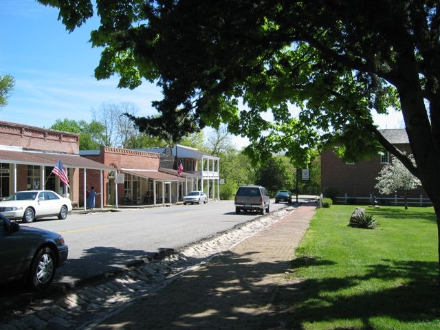
Arrow Rock is a town in Saline County, Missouri, with 60 residents (2020 Census). It sits at 709 ft (216 m) above sea level. The nearest town is Blackwater, 6.7 miles S.
- 60residents (2020 Census)
- 709 ftelevation · 216 m
- 0.1 sq miland area · 0.3 km²
- 450 / sq mipopulation density
- 65320ZIP code
About Arrow Rock
Arrow Rock is a village in Saline County, Missouri, United States, located near the Missouri River. The entire village is part of the National Historic Landmark Arrow Rock Historic District, designated by the Department of the Interior, National Park Service in 1963. It is significant in the history of Westward Expansion, the Santa Fe Trail, and 19th-century artist George Caleb Bingham. The town is well known for the Arrow Rock Lyceum Theatre, hosting over 33,000 patrons every year.
The first state-designated historic site is located here. Restoration of a 19th-century tavern in 1923 marked the beginning of historic preservation in Missouri. Many structures within the village are individually listed on the National Register of Historic Places. Several locations are also certified sites of the Lewis and Clark National Historic Trail and the Santa Fe National Historic Trail.
The village retains much of its 19th-century Boonslick character, and it attracts more than 100,000 visitors per year. Given the importance of heritage tourism to the village's economy, architectural ordinances implemented in 2004 provide guidance for both new construction and restorations of existing structures.
The town has numerous bed and breakfast establishments, and a modern campground nearby is maintained by the Missouri Division of State Parks. Local government consists of an elected five-member Board of Trustees. The Trustees elect their chair person (mayor).
Text: Wikipedia · CC BY-SA 4.0
Arrow Rock weather: 7-day forecast
Loading the National Weather Service forecast…
Source: National Weather Service (NOAA).
Nearest webcams to Arrow Rock
There are no webcams in Arrow Rock itself. These are the closest, 62 miles away or more.
Webcams: Windy.com
Living in Arrow Rock
- Median household income
- $35,469
- Median home value
- $278,800
- Median age
- 51.8
Do you know Arrow Rock? Tell us about it
Help other travelers: share what makes Arrow Rock special. We review every message before publishing it.
Map of Arrow Rock
Tap any street on the map to see it in Street View below. Map: © OpenStreetMap contributors.
Arrow Rock Street View
Drag the image to look around and tap the arrows on the ground to move. If it says there is no imagery, tap a nearby street on the map above.
Open in Google Maps ›Arrow Rock, MO population
Arrow Rock had 60 residents in the 2020 Census.
| 2020 Census | 60 |
|---|---|
| Density | 450 per sq mi (174 per km²) |
Source: U.S. Census Bureau, Decennial Census.
Arrow Rock at a glance
| State | Missouri (MO) |
|---|---|
| County | Saline County |
| Type | Town |
| Population | 60 (2020) |
| Land area | 0.13 sq mi (0.3 km²) |
| Elevation | 709 ft (216 m) |
| Coordinates | 39.0700° N, 92.9472° W |
| ZIP code | 65320 |
| Official website | arrowrock.org |
| Census code (GEOID) | 2902044 |
Sources: U.S. Census Bureau (Gazetteer, ZCTA), USGS GNIS, Wikidata.
Towns near Arrow Rock
- Blackwater6.7 mi S
- Nelson6.9 mi SW
- Franklin11.0 mi E
- New Franklin11.5 mi E
- Gilliam11.7 mi N
- Slater12.3 mi NW
- Glasgow12.4 mi NE
- Boonville13.1 mi SE
- Pilot Grove13.7 mi S
- Marshall14.0 mi W
- Fayette15.0 mi E
- Windsor Place16.1 mi SE
Straight-line distance between town centers.
Frequently asked questions about Arrow Rock
What county is Arrow Rock in?
Arrow Rock is in Saline County, Missouri.
What is the population of Arrow Rock, MO?
60 people lived in Arrow Rock at the 2020 Census.
What is the ZIP code of Arrow Rock, MO?
The ZIP code of Arrow Rock is 65320.
What is the elevation of Arrow Rock?
709 feet (216 m) above sea level.
What towns are near Arrow Rock?
Blackwater (6.7 mi), Nelson (6.9 mi), Franklin (11.0 mi), New Franklin (11.5 mi), Gilliam (11.7 mi).
Last updated: