Andrews AFB
Census-designated place in Prince George's County, Maryland
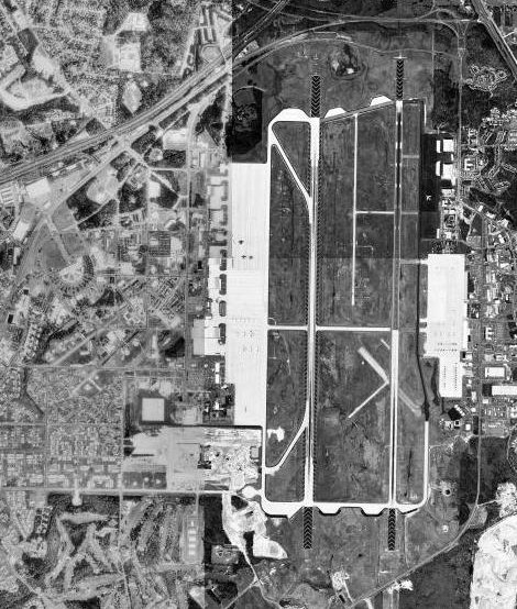
Andrews AFB is an unincorporated community (census-designated place) in Prince George's County, Maryland, with 3,025 residents (2020 Census). It sits at 279 ft (85 m) above sea level. The nearest town is Melwood, 1.6 miles E.
- 3,025residents (2020 Census)
- 279 ftelevation · 85 m
- 6.9 sq miland area · 18.0 km²
- 436 / sq mipopulation density
- 20762ZIP code
About Andrews AFB
Joint Base Andrews (JBA; IATA: ADW, ICAO: KADW, FAA LID: ADW) is a United States military facility located in Prince George's County, Maryland. The facility is under the jurisdiction of the United States Air Force (USAF) 316th Wing, Air Force District of Washington (AFDW). The base was established in 2009, when Andrews Air Force Base and Naval Air Facility Washington were merged.
The base is named for Lieutenant General Frank Maxwell Andrews (1884–1943), former commanding general of United States Armed Forces in the European Theater of Operations during World War II. The base is widely known for serving as the home base of two Boeing VC-25 aircraft which have the call sign Air Force One while the president of the United States is on board.
The host at Andrews is the 316th Wing, assigned to the Air Force District of Washington, which is also headquartered at Andrews. The 316th Wing is responsible for maintaining emergency reaction rotary-wing airlift and other National Capital Region contingency response capabilities critical to national security, and for organizing, training, equipping and deploying combat-ready forces for Air and Space Expeditionary Forces (AEFs). Three other wings at Andrews are the reserve 459th Air Refueling Wing, Air National Guard's 113th Wing and active duty 89th Airlift Wing.
Text: Wikipedia · CC BY-SA 4.0
Andrews AFB weather: 7-day forecast
Loading the National Weather Service forecast…
Source: National Weather Service (NOAA).
Live webcams in Andrews AFB
Webcams: Windy.com
Living in Andrews AFB
- Median household income
- $87,407
- Median rent
- $2,699/mo
- Median age
- 24.4
Do you know Andrews AFB? Tell us about it
Help other travelers: share what makes Andrews AFB special. We review every message before publishing it.
Map of Andrews AFB
Tap any street on the map to see it in Street View below. Map: © OpenStreetMap contributors.
Andrews AFB Street View
Drag the image to look around and tap the arrows on the ground to move. If it says there is no imagery, tap a nearby street on the map above.
Open in Google Maps ›Andrews AFB, MD population
Andrews AFB had 3,025 residents in the 2020 Census.
| 2020 Census | 3,025 |
|---|---|
| Density | 436 per sq mi (168 per km²) |
Source: U.S. Census Bureau, Decennial Census.
Andrews AFB at a glance
| State | Maryland (MD) |
|---|---|
| County | Prince George's County |
| Type | Census-designated place |
| Population | 3,025 (2020) |
| Land area | 6.93 sq mi (18.0 km²) |
| Water area | 0.04 sq mi (0.09 km²) |
| Elevation | 279 ft (85 m) |
| Coordinates | 38.8098° N, 76.8692° W |
| ZIP code | 20762 |
| Official website | jba.af.mil |
| Census code (GEOID) | 2401450 |
Sources: U.S. Census Bureau (Gazetteer, ZCTA), USGS GNIS, Wikidata.
Towns near Andrews AFB
- Melwood1.6 mi E
- Morningside1.6 mi NW
- Camp Springs2.7 mi W
- Forestville2.8 mi N
- Westphalia3.1 mi NE
- District Heights3.5 mi N
- Rosaryville3.7 mi SE
- Suitland3.9 mi NW
- Marlow Heights3.9 mi W
- Queensland4.1 mi E
- Silver Hill4.3 mi NW
- Temple Hills4.3 mi W
Straight-line distance between town centers.
Frequently asked questions about Andrews AFB
What county is Andrews AFB in?
Andrews AFB is in Prince George's County, Maryland.
What is the population of Andrews AFB, MD?
3,025 people lived in Andrews AFB at the 2020 Census.
What is the ZIP code of Andrews AFB, MD?
The ZIP code of Andrews AFB is 20762.
What is the elevation of Andrews AFB?
279 feet (85 m) above sea level.
What towns are near Andrews AFB?
Melwood (1.6 mi), Morningside (1.6 mi), Camp Springs (2.7 mi), Forestville (2.8 mi), Westphalia (3.1 mi).
Last updated: