St. Mary of the Woods
Census-designated place in Vigo County, Indiana
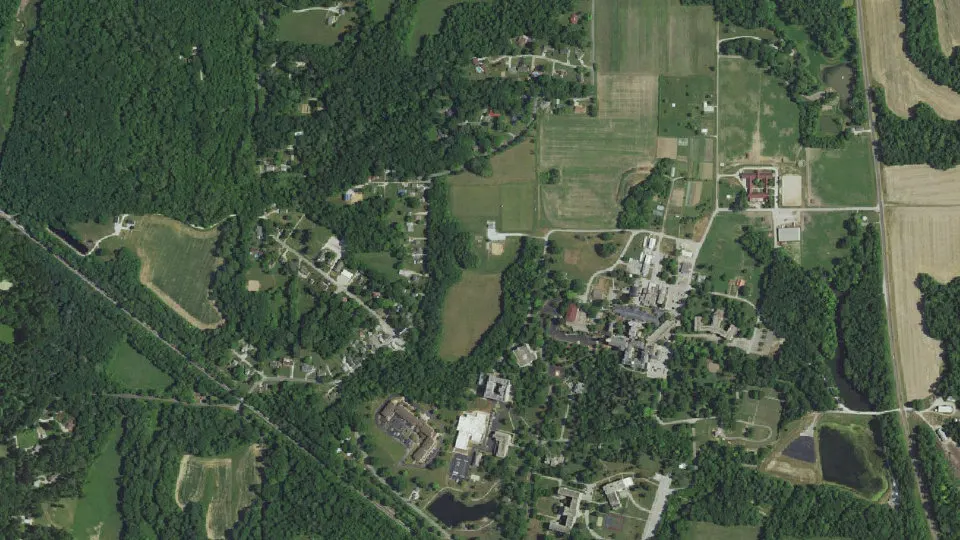
St. Mary of the Woods is an unincorporated community (census-designated place) in Vigo County, Indiana, with 767 residents (2020 Census). It sits at 784 ft (239 m) above sea level. The nearest town is West Terre Haute, 3.4 miles S.
- 767residents (2020 Census)
- 784 ftelevation · 239 m
- 1.2 sq miland area · 3.2 km²
- 619 / sq mipopulation density
- 47876main ZIP code (2 in total)
About St. Mary of the Woods
Saint Mary-of-the-Woods, often called St. Mary's, is an unincorporated community in Sugar Creek Township in northwestern Vigo County, in the U.S. state of Indiana. The community is part of the Terre Haute Metropolitan Statistical Area. A large portion of Saint Mary-of-the-Woods along U.S. Route 150 is taken up by the grounds of the Sisters of Providence of Saint Mary-of-the-Woods, which contain the motherhouse of the Sisters of Providence as well as Saint Mary-of-the-Woods College.
Although Saint Mary-of-the-Woods is unincorporated, it has a post office, with the ZIP code of 47876. It had a population of 797 at the 2010 census.
Text: Wikipedia · CC BY-SA 4.0
St. Mary of the Woods weather: 7-day forecast
Loading the National Weather Service forecast…
Source: National Weather Service (NOAA).
Live webcams in St. Mary of the Woods
Webcams: Windy.com
Things to do in St. Mary of the Woods
Top places to visit in and around St. Mary of the Woods: Swope Art Museum, Paul Dresser Birthplace and CANDLES Holocaust Museum and Education Center.
 Swope Art MuseumMuseum · 4.4 mi SE
 Paul Dresser BirthplaceMuseum · 4.6 mi SECANDLES Holocaust Museum and Education CenterMuseum · 4.4 mi SE
 Church of the Immaculate ConceptionHistoric church · in town
Museums & galleries (3)Historic sites & landmarks (10)Theaters & public art (4)
All 17 things to do in St. Mary of the Woods ›Living in St. Mary of the Woods
- Median household income
- $28,114
- Median rent
- $490/mo
- Median age
- 53.5
Small communities near St. Mary of the Woods
- Whitcomb Heights1.7 mi S
- Liggett2.5 mi SW
- Spelterville3.7 mi E
- Twelve Points3.8 mi E
- Larimer Hill3.9 mi S
- Taylorville4.1 mi SE
- West New Goshen4.1 mi N
- Sandford4.2 mi NW
- Duane Yards4.2 mi E
- West Sandford4.4 mi NW
- Dewey4.7 mi E
- Terre Town4.8 mi E
- Preston5.0 mi E
- State Line6.2 mi SW
- Elbridge6.3 mi W
- Shirkieville6.3 mi N
Schools near St. Mary of the Woods
There are no public schools inside St. Mary of the Woods. The nearest elementary school is Ouabache Elementary School (3.2 mi SE); the nearest middle school is West Vigo Middle School (3.8 mi S); the nearest high school is West Vigo High School (3.7 mi S).
| School | Grades | Students | Students per teacher | Type | Distance |
|---|---|---|---|---|---|
| Ouabache Elementary School Terre Haute · Vigo County School Corp | PK–5 | 366 | 11.4 | Public | 3.2 mi SE |
| West Vigo High School West Terre Haute · Vigo County School Corp | 9–12 | 531 | 10.6 | Public | 3.7 mi S |
| West Vigo Middle School West Terre Haute · Vigo County School Corp | 6–8 | 390 | 11.8 | Public | 3.8 mi S |
| Terre Town Elementary School Terre Haute · Vigo County School Corp | PK–5 | 553 | 14.9 | Public | 4.2 mi E |
| Sugar Creek Consolidated Elem Sch West Terre Haute · Vigo County School Corp | PK–5 | 452 | 14.1 | Public | 4.3 mi S |
| Deming Early Learning Center Terre Haute · Vigo County School Corp | PK–3 | 306 | 17.0 | Public | 4.4 mi SE |
Do you know St. Mary of the Woods? Tell us about it
Help other travelers: share what makes St. Mary of the Woods special. We review every message before publishing it.
Map of St. Mary of the Woods
Tap any street on the map to see it in Street View below. Map: © OpenStreetMap contributors.
St. Mary of the Woods Street View
Drag the image to look around and tap the arrows on the ground to move. If it says there is no imagery, tap a nearby street on the map above.
Open in Google Maps ›St. Mary of the Woods, IN population
St. Mary of the Woods had 767 residents in the 2020 Census.
| 2020 Census | 767 |
|---|---|
| Density | 619 per sq mi (239 per km²) |
Source: U.S. Census Bureau, Decennial Census.
St. Mary of the Woods at a glance
| State | Indiana (IN) |
|---|---|
| County | Vigo County |
| Type | Census-designated place |
| Population | 767 (2020) |
| Land area | 1.24 sq mi (3.2 km²) |
| Water area | 0.02 sq mi (0.05 km²) |
| Elevation | 784 ft (239 m) |
| Coordinates | 39.5122° N, 87.4645° W |
| ZIP codes | 47876, 47885 |
| Census code (GEOID) | 1867050 |
Sources: U.S. Census Bureau (Gazetteer, ZCTA), USGS GNIS, Wikidata.
Towns near St. Mary of the Woods
- West Terre Haute3.4 mi S
- Toad Hop3.7 mi S
- Dresser4.0 mi SE
- Tecumseh4.5 mi NE
- New Goshen4.7 mi N
- North Terre Haute5.6 mi E
- Terre Haute5.8 mi SE
- Shepardsville6.8 mi N
- Libertyville7.0 mi NW
- Universal7.6 mi N
- Vermilion, IL8.1 mi NW
- Burnett9.1 mi E
Straight-line distance between town centers.
Frequently asked questions about St. Mary of the Woods
What county is St. Mary of the Woods in?
St. Mary of the Woods is in Vigo County, Indiana.
What is the population of St. Mary of the Woods, IN?
767 people lived in St. Mary of the Woods at the 2020 Census.
What is the ZIP code of St. Mary of the Woods, IN?
The main ZIP code is 47876. Other ZIP codes: 47885.
What is the elevation of St. Mary of the Woods?
784 feet (239 m) above sea level.
What towns are near St. Mary of the Woods?
West Terre Haute (3.4 mi), Toad Hop (3.7 mi), Dresser (4.0 mi), Tecumseh (4.5 mi), New Goshen (4.7 mi).
Last updated: