Maunawili
Census-designated place in Honolulu County, Hawaii
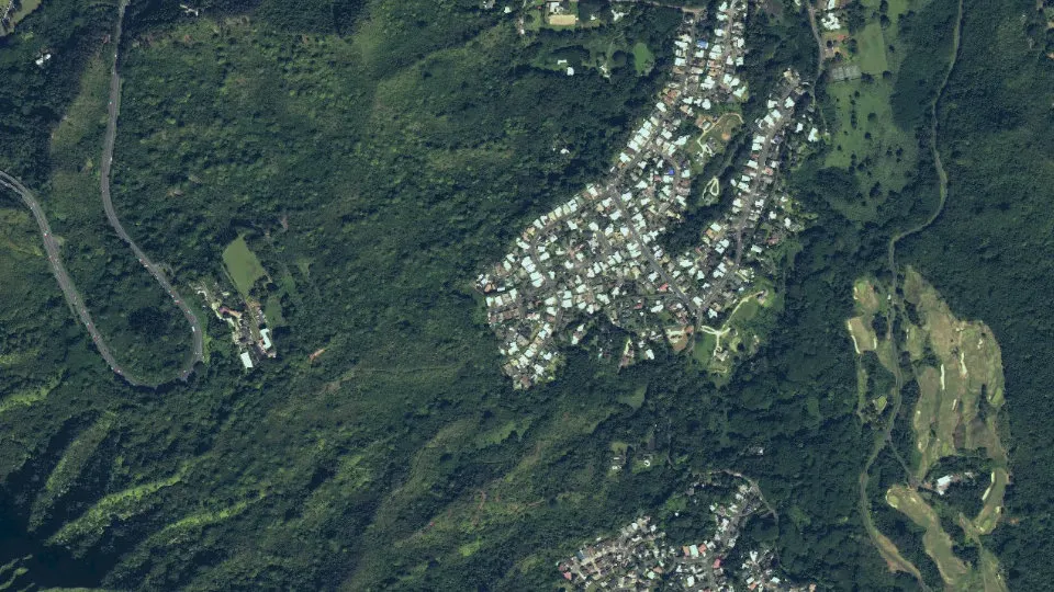
Maunawili is an unincorporated community (census-designated place) in Honolulu County, Hawaii, with 2,026 residents (2020 Census). It sits at 69 ft (21 m) above sea level. The nearest town is Kailua, 3.1 miles NE.
- 2,026residents (2020 Census)
- 69 ftelevation · 21 m
- 1.8 sq miland area · 4.7 km²
- 1,108 / sq mipopulation density
- 96734ZIP code
About Maunawili
Maunawili (Hawaiian pronunciation: [mɐwnəˈvili] ) is a residential census-designated place (CDP) in the City & County of Honolulu, Koʻolaupoko District, Island of Oʻahu, Hawaii, United States. As of the 2020 census, the CDP had a population of 2,026. Situated mauka (inland or mountain side) of Kalanianaʻole Highway between Castle Junction and Castle Hospital, Maunawili is nearly all private homes, schools, and a few churches; horse stables complete the rural setting. There are no commercial establishments. However, residents are only minutes (by car or bus) from Kailua.
Maunawili Valley extends behind the prominent windward peak known as Olomana. The residential developments extend only part way back into the valley, which is quite large and fairly wet, supporting limited agriculture (mostly banana growing) behind the housing. Water from the numerous streams is diverted by a ditch to much drier Waimānalo to support agricultural activities there.
A golf course and the Hawaiian Agriculture Research Center are located in the valley. The agriculture research station is also home to a sugar cane, coffee and cacao breeding program. An attraction of increasing popularity is the Maunawili Demonstration Trail, a state-maintained trail that traverses the breadth of upper Maunawili Valley from the Pali Highway (access at the "Horseshoe Curve") to Waimānalo. A connecting side trail (Maunawili Falls Trail) is accessible from the neighborhood in upper Maunawili.
The U.S. postal code for Maunawili is the same as for Kailua: 96734.
Text: Wikipedia · CC BY-SA 4.0
Maunawili weather: 7-day forecast
Loading the National Weather Service forecast…
Source: National Weather Service (NOAA).
Live webcams in Maunawili
Webcams: Windy.com
Living in Maunawili
- Median household income
- $177,143
- Median home value
- $1,511,300
- Median rent
- $3,501/mo
- Median age
- 56.3
Do you know Maunawili? Tell us about it
Help other travelers: share what makes Maunawili special. We review every message before publishing it.
Map of Maunawili
Tap any street on the map to see it in Street View below. Map: © OpenStreetMap contributors.
Maunawili Street View
Drag the image to look around and tap the arrows on the ground to move. If it says there is no imagery, tap a nearby street on the map above.
Open in Google Maps ›Maunawili, HI population
Maunawili had 2,026 residents in the 2020 Census.
| 2020 Census | 2,026 |
|---|---|
| Density | 1,108 per sq mi (428 per km²) |
Source: U.S. Census Bureau, Decennial Census.
Maunawili at a glance
| State | Hawaii (HI) |
|---|---|
| County | Honolulu County |
| Type | Census-designated place |
| Population | 2,026 (2020) |
| Land area | 1.83 sq mi (4.7 km²) |
| Elevation | 69 ft (21 m) |
| Coordinates | 21.3667° N, 157.7713° W |
| ZIP code | 96734 |
| Census code (GEOID) | 1550750 |
Sources: U.S. Census Bureau (Gazetteer, ZCTA), USGS GNIS, Wikidata.
Towns near Maunawili
- Kailua3.1 mi NE
- Waimanalo3.1 mi SE
- Kaneohe3.2 mi N
- Heeia4.8 mi NW
- Kaneohe Base5.6 mi N
- Waimanalo Beach5.6 mi SE
- Urban Honolulu5.7 mi SW
- East Honolulu6.4 mi SE
- Ahuimanu6.6 mi NW
- Kahaluu7.7 mi NW
- Halawa9.5 mi W
- Aiea10.0 mi W
Straight-line distance between town centers.
Frequently asked questions about Maunawili
What county is Maunawili in?
Maunawili is in Honolulu County, Hawaii.
What is the population of Maunawili, HI?
2,026 people lived in Maunawili at the 2020 Census.
What is the ZIP code of Maunawili, HI?
The ZIP code of Maunawili is 96734.
What is the elevation of Maunawili?
69 feet (21 m) above sea level.
What towns are near Maunawili?
Kailua (3.1 mi), Waimanalo (3.1 mi), Kaneohe (3.2 mi), Heeia (4.8 mi), Kaneohe Base (5.6 mi).
Last updated: