Kalaeloa
Census-designated place in Honolulu County, Hawaii
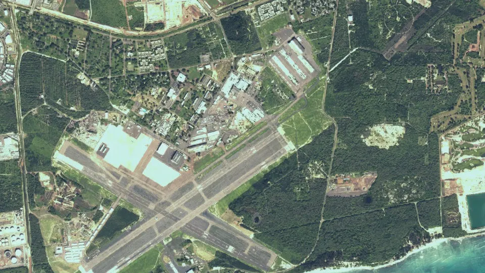
Kalaeloa is an unincorporated community (census-designated place) in Honolulu County, Hawaii, with 2,364 residents (2020 Census). It sits at 30 ft (9 m) above sea level. The nearest town is Kapolei, 1.8 miles N.
- 2,364residents (2020 Census)
- 30 ftelevation · 9 m
- 6.1 sq miland area · 15.8 km²
- 388 / sq mipopulation density
- 96706ZIP code
About Kalaeloa
Kalaeloa (Hawaiian pronunciation: [kəlɐe̯ˈlowə]) is a census-designated place (CDP) in Honolulu County, Hawaii, United States. The population was 2,364 at the 2020 census. The community occupies the location of the former Naval Air Station Barbers Point, which was closed in 1999 and subsequently transferred to the State of Hawaiʻi. The geographical name, Ka lae loa, means "long point" in Hawaiian and is the native name for what was also called Barbers Point. The English name came from Captain Henry Barber who wrecked his ship on a shoal there on October 31, 1796.
In 1993, after the federal government listed Barbers Point for closure, the state legislature established the Barbers Point Naval Air Station Redevelopment Commission (BPNAS-RC) to guide the redevelopment of the former military facilities comprising John Rodgers airfield and 3,700 acres (15 km2) of land along the south shore of Oʻahu between the towns of ʻEwa, Kapolei, and Campbell Industrial Park. On July 1, 2002, the Hawaii Community Development Authority became the redevelopment authority for Kalaeloa. The former Naval Air Station runways and associated facilities are now Kalaeloa Airport.
Barbers Point Housing is that part of Kalaeloa retained temporarily by the United States Navy for housing.
Text: Wikipedia · CC BY-SA 4.0
Kalaeloa weather: 7-day forecast
Loading the National Weather Service forecast…
Source: National Weather Service (NOAA).
Live webcams in Kalaeloa
Webcams: Windy.com
Living in Kalaeloa
- Median household income
- $90,313
- Median rent
- $3,141/mo
- Median age
- 33
Do you know Kalaeloa? Tell us about it
Help other travelers: share what makes Kalaeloa special. We review every message before publishing it.
Map of Kalaeloa
Tap any street on the map to see it in Street View below. Map: © OpenStreetMap contributors.
Kalaeloa Street View
Drag the image to look around and tap the arrows on the ground to move. If it says there is no imagery, tap a nearby street on the map above.
Open in Google Maps ›Kalaeloa, HI population
Kalaeloa had 2,364 residents in the 2020 Census.
| 2020 Census | 2,364 |
|---|---|
| Density | 388 per sq mi (150 per km²) |
Source: U.S. Census Bureau, Decennial Census.
Kalaeloa at a glance
| State | Hawaii (HI) |
|---|---|
| County | Honolulu County |
| Type | Census-designated place |
| Population | 2,364 (2020) |
| Land area | 6.10 sq mi (15.8 km²) |
| Elevation | 30 ft (9 m) |
| Coordinates | 21.3135° N, 158.0650° W |
| ZIP code | 96706 |
| Census code (GEOID) | 1524850 |
Sources: U.S. Census Bureau (Gazetteer, ZCTA), USGS GNIS, Wikidata.
Towns near Kalaeloa
- Kapolei1.8 mi N
- Ocean Pointe2.5 mi E
- Ewa Villages2.6 mi NE
- Ewa Gentry2.9 mi NE
- Makakilo3.3 mi N
- East Kapolei3.8 mi NE
- Ewa Beach3.8 mi E
- Ko Olina3.8 mi NW
- West Loch Estate4.2 mi NE
- Iroquois Point5.7 mi E
- Waipahu6.0 mi NE
- Royal Kunia6.7 mi N
Straight-line distance between town centers.
Frequently asked questions about Kalaeloa
What county is Kalaeloa in?
Kalaeloa is in Honolulu County, Hawaii.
What is the population of Kalaeloa, HI?
2,364 people lived in Kalaeloa at the 2020 Census.
What is the ZIP code of Kalaeloa, HI?
The ZIP code of Kalaeloa is 96706.
What is the elevation of Kalaeloa?
30 feet (9 m) above sea level.
What towns are near Kalaeloa?
Kapolei (1.8 mi), Ocean Pointe (2.5 mi), Ewa Villages (2.6 mi), Ewa Gentry (2.9 mi), Makakilo (3.3 mi).
Last updated: