University of California-Santa Barbara
Census-designated place in Santa Barbara County, California
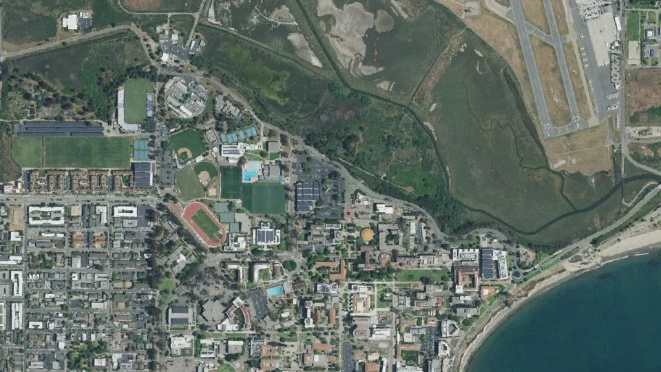
University of California-Santa Barbara is an unincorporated community (census-designated place) in Santa Barbara County, California, with 9,710 residents (2020 Census). The nearest town is Isla Vista, 0.9 miles SW.
- 9,710residents (2020 Census)
- 1.3 sq miland area · 3.4 km²
- 7,471 / sq mipopulation density
- 93106ZIP code
About University of California-Santa Barbara
The University of California, Santa Barbara (UC Santa Barbara or UCSB) is a public land-grant research university in Santa Barbara County, California, United States. Tracing its roots back to 1891 as an independent teachers college, UC Santa Barbara joined the University of California system in 1944. It is the third-oldest campus in the system, after Berkeley, and UCLA.
UCSB's campus sits on the oceanfront site of a converted WWII-era Marine Corps air station. UCSB is organized into three undergraduate colleges (Letters and Science, Engineering, and Creative Studies) and two graduate schools (Education and Environment), offering more than 200 degrees and programs. It is classified among "R1: Doctoral Universities – Very high research activity" and is regarded as a Public Ivy. The university has 12 national research centers and institutes, including the Kavli Institute for Theoretical Physics and NSF Quantum Foundry. According to the National Science Foundation, UC Santa Barbara spent $305.48 million on research and development in fiscal year 2023, ranking it 105th in the nation. UCSB was the No. 3 host on the ARPAnet and was elected to the Association of American Universities in 1995.
UCSB alumni, faculty, and researchers have included 11 Nobel Prize laureates, founders of more than 90 companies, 1 Fields Medalist, 50 members of the National Academy of Sciences, 34 members of the National Academy of Engineering, and 56 members of the American Academy of Arts and Sciences. The faculty also includes two Academy and Emmy Award winners and recipients of a Millennium Technology Prize, an IEEE Medal of Honor, a National Medal of Technology and Innovation, a Breakthrough Prize in Fundamental Physics, and a Dan David Prize.
Text: Wikipedia · CC BY-SA 4.0
University of California-Santa Barbara weather: 7-day forecast
Loading the National Weather Service forecast…
Source: National Weather Service (NOAA).
Live webcams in University of California-Santa Barbara
All 24 webcams near University of California-Santa Barbara ›Things to do in University of California-Santa Barbara
Top places to visit in and around University of California-Santa Barbara: Art, Design and Architecture Museum at UCSB, South Coast Railroad Museum and Ty Warner Sea Center.
 Art, Design and Architecture Museum at UCSBMuseum · in town
 South Coast Railroad MuseumMuseum · 1.7 mi N
 Ty Warner Sea CenterZoo · 9.2 mi E
 Santa Barbara ZooZoo · 10 mi E
Tourist attractions (1)Family attractions (2)Museums & galleries (10)Historic sites & landmarks (5)Parks & gardens (10)Beaches (5)Scenic viewpoints & peaks (5)Nature reserves & natural wonders (7)Theaters & public art (4)
All 49 things to do in University of California-Santa Barbara ›Living in University of California-Santa Barbara
- Median household income
- $69,327
- Median home value
- $452,900
- Median rent
- $1,526/mo
- Median age
- 20
Small communities near University of California-Santa Barbara
Schools near University of California-Santa Barbara
There are no public schools inside University of California-Santa Barbara. The nearest elementary school is Isla Vista Elementary (1.3 mi W); the nearest middle school is Goleta Valley Junior High (2.3 mi N); the nearest high school is Dos Pueblos Senior High (2.3 mi NW).
| School | Grades | Students | Students per teacher | Type | Distance |
|---|---|---|---|---|---|
| Isla Vista Elementary Goleta · Goleta Union Elementary | K–6 | 418 | 19.9 | Public | 1.3 mi W |
| La Patera Elementary Goleta · Goleta Union Elementary | K–6 | 369 | 18.5 | Public | 2.1 mi N |
| Santa Barbara Charter Goleta · Santa Barbara Unified | K–8 | 269 | 22.4 | Charter | 2.3 mi N |
| Goleta Valley Junior High Goleta · Santa Barbara Unified | 7–8 | 731 | 19.8 | Public | 2.3 mi N |
| Dos Pueblos Senior High Goleta · Santa Barbara Unified | 9–12 | 2,149 | 22.6 | Public | 2.3 mi NW |
| Kellogg Elementary Goleta · Goleta Union Elementary | K–6 | 369 | 21.7 | Public | 2.5 mi NE |
All schools in and near University of California-Santa Barbara ›
Do you know University of California-Santa Barbara? Tell us about it
Help other travelers: share what makes University of California-Santa Barbara special. We review every message before publishing it.
Map of University of California-Santa Barbara
Tap any street on the map to see it in Street View below. Map: © OpenStreetMap contributors.
University of California-Santa Barbara Street View
Drag the image to look around and tap the arrows on the ground to move. If it says there is no imagery, tap a nearby street on the map above.
Open in Google Maps ›University of California-Santa Barbara, CA population
University of California-Santa Barbara had 9,710 residents in the 2020 Census.
| 2020 Census | 9,710 |
|---|---|
| Density | 7,471 per sq mi (2,885 per km²) |
Source: U.S. Census Bureau, Decennial Census.
University of California-Santa Barbara at a glance
| State | California (CA) |
|---|---|
| County | Santa Barbara County |
| Type | Census-designated place |
| Population | 9,710 (2020) |
| Land area | 1.30 sq mi (3.4 km²) |
| Water area | 0.12 sq mi (0.30 km²) |
| Coordinates | 34.4178° N, 119.8467° W |
| ZIP code | 93106 |
| Census code (GEOID) | 0681316 |
Sources: U.S. Census Bureau (Gazetteer, ZCTA), USGS GNIS, Wikidata.
Towns near University of California-Santa Barbara
- Isla Vista0.9 mi SW
- Goleta1.4 mi NW
- Eastern Goleta Valley4.2 mi NE
- Santa Barbara7.6 mi E
- Mission Canyon7.9 mi E
- Montecito12.2 mi E
- Summerland14.8 mi E
- Toro Canyon16.2 mi E
- Carpinteria19.4 mi E
- Santa Ynez19.8 mi NW
- Solvang20.6 mi NW
- Ballard21.6 mi NW
Straight-line distance between town centers.
Frequently asked questions about University of California-Santa Barbara
What county is University of California-Santa Barbara in?
University of California-Santa Barbara is in Santa Barbara County, California.
What is the population of University of California-Santa Barbara, CA?
9,710 people lived in University of California-Santa Barbara at the 2020 Census.
What is the ZIP code of University of California-Santa Barbara, CA?
The ZIP code of University of California-Santa Barbara is 93106.
What towns are near University of California-Santa Barbara?
Isla Vista (0.9 mi), Goleta (1.4 mi), Eastern Goleta Valley (4.2 mi), Santa Barbara (7.6 mi), Mission Canyon (7.9 mi).
Last updated: