University of California-Davis
Census-designated place in Yolo County, California
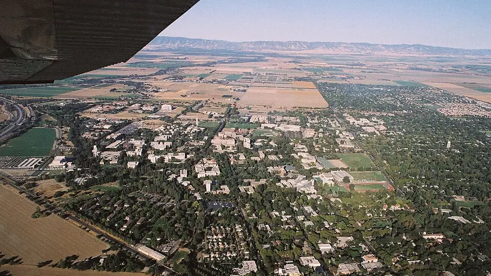
University of California-Davis is an unincorporated community (census-designated place) in Yolo County, California, with 8,525 residents (2020 Census). The nearest town is Davis, 1.7 miles NE.
- 8,525residents (2020 Census)
- 1.6 sq miland area · 4.3 km²
- 5,189 / sq mipopulation density
- 95616ZIP code
About University of California-Davis
The University of California, Davis (UC Davis, UCD, or Davis) is a public land-grant research university in the Davis, California area, United States. It is the northernmost of the ten campuses of the University of California system. The institution was first founded as an agricultural branch of the system in 1905 and became the sixth campus of the University of California in 1959.
Founded as a primarily agricultural campus, the university has expanded over the past century to include graduate and professional programs in medicine (which includes the UC Davis Medical Center), engineering, science, law, veterinary medicine, education, nursing, and business management, in addition to 90 research programs offered by UC Davis Graduate Studies. The UC Davis School of Veterinary Medicine is the largest veterinary school in the United States. UC Davis also offers certificates and courses, including online classes, for adults and non-traditional learners through its Division of Continuing and Professional Education.
It is classified among "R1: Doctoral Universities – Very high research activity" and is considered a "Public Ivy". The UC Davis Aggies athletic teams compete in NCAA Division I, primarily as members of the Mountain West Conference with additional sports in the Big Sky Conference (football only), the Mountain Pacific Sports Federation, and the West Coast Conference. Athletes from UC Davis have won a total of 10 Olympic medals.
Text: Wikipedia · CC BY-SA 4.0
University of California-Davis weather: 7-day forecast
Loading the National Weather Service forecast…
Source: National Weather Service (NOAA).
Live webcams in University of California-Davis
Webcams: Windy.com
Things to do in University of California-Davis
Top places to visit in and around University of California-Davis: Bohart Museum of Entomology, Sacramento Zoo and University of California, Davis, Arboretum and Public Garden.
 Bohart Museum of EntomologyMuseum · in town
 Sacramento ZooZoo · 14 mi E
 University of California, Davis, Arboretum and Public GardenGarden · in town
 Crocker Art MuseumMuseum · 14 mi E
Family attractions (1)Museums & galleries (10)Historic sites & landmarks (10)Parks & gardens (3)Nature reserves & natural wonders (5)Theaters & public art (10)
All 39 things to do in University of California-Davis ›Living in University of California-Davis
- Median household income
- $18,631
- Median rent
- $1,678/mo
- Median age
- 19.3
Small communities near University of California-Davis
Schools near University of California-Davis
There are no public schools inside University of California-Davis. The nearest elementary school is Cesar Chavez Elementary (1.2 mi N); the nearest middle school is Ralph Waldo Emerson Junior High (1.4 mi NW); the nearest high school is Martin Luther King High (1.0 mi NE).
| School | Grades | Students | Students per teacher | Type | Distance |
|---|---|---|---|---|---|
| Davis School for Independent Study Davis · Davis Joint Unified | K–12 | 124 | 12.4 | Public | 1.0 mi NE |
| Martin Luther King High Davis · Davis Joint Unified | 9–12 | 51 | 12.8 | Public | 1.0 mi NE |
| Cesar Chavez Elementary Davis · Davis Joint Unified | K–6 | 510 | 24.3 | Public | 1.2 mi N |
| Robert E. Willett Elementary Davis · Davis Joint Unified | K–6 | 506 | 23.0 | Public | 1.2 mi N |
| Davis Senior High Davis · Davis Joint Unified | 10–12 | 1,755 | 23.1 | Public | 1.3 mi N |
| Ralph Waldo Emerson Junior High Davis · Davis Joint Unified | 7–9 | 524 | 19.4 | Public | 1.4 mi NW |
Do you know University of California-Davis? Tell us about it
Help other travelers: share what makes University of California-Davis special. We review every message before publishing it.
Map of University of California-Davis
Tap any street on the map to see it in Street View below. Map: © OpenStreetMap contributors.
University of California-Davis Street View
Drag the image to look around and tap the arrows on the ground to move. If it says there is no imagery, tap a nearby street on the map above.
Open in Google Maps ›University of California-Davis, CA population
University of California-Davis had 8,525 residents in the 2020 Census.
| 2020 Census | 8,525 |
|---|---|
| Density | 5,189 per sq mi (2,004 per km²) |
Source: U.S. Census Bureau, Decennial Census.
University of California-Davis at a glance
| State | California (CA) |
|---|---|
| County | Yolo County |
| Type | Census-designated place |
| Population | 8,525 (2020) |
| Land area | 1.64 sq mi (4.3 km²) |
| Coordinates | 38.5378° N, 121.7587° W |
| ZIP code | 95616 |
| Official website | ucdavis.edu |
| Census code (GEOID) | 0681302 |
Sources: U.S. Census Bureau (Gazetteer, ZCTA), USGS GNIS, Wikidata.
Towns near University of California-Davis
- Davis1.7 mi NE
- El Macero4.0 mi E
- Dixon7.2 mi SW
- Woodland9.3 mi N
- Monument Hills10.8 mi NW
- West Sacramento11.4 mi E
- Winters11.7 mi W
- Hartley13.2 mi SW
- Allendale13.8 mi SW
- Yolo14.3 mi N
- Clarksburg14.3 mi SE
- Freeport14.8 mi E
Straight-line distance between town centers.
Frequently asked questions about University of California-Davis
What county is University of California-Davis in?
University of California-Davis is in Yolo County, California.
What is the population of University of California-Davis, CA?
8,525 people lived in University of California-Davis at the 2020 Census.
What is the ZIP code of University of California-Davis, CA?
The ZIP code of University of California-Davis is 95616.
What towns are near University of California-Davis?
Davis (1.7 mi), El Macero (4.0 mi), Dixon (7.2 mi), Woodland (9.3 mi), Monument Hills (10.8 mi).
Last updated: