Twin Lakes
Census-designated place in Santa Cruz County, California
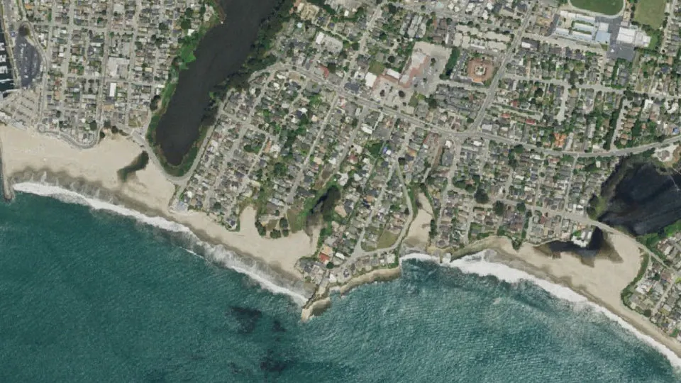
Twin Lakes is an unincorporated community (census-designated place) in Santa Cruz County, California, with 4,944 residents (2020 Census). It sits at 52 ft (16 m) above sea level. The nearest town is Pleasure Point, 1.2 miles E.
- 4,944residents (2020 Census)
- 52 ftelevation · 16 m
- 0.7 sq miland area · 1.8 km²
- 7,162 / sq mipopulation density
- 95062ZIP code
About Twin Lakes
Twin Lakes is a census-designated place (CDP) in Santa Cruz County, California, United States. The population was 4,944 at the 2020 census, up from 4,917 at the 2010 census.
Text: Wikipedia · CC BY-SA 4.0
Twin Lakes weather: 7-day forecast
Loading the National Weather Service forecast…
Source: National Weather Service (NOAA).
Live webcams in Twin Lakes
All 24 webcams near Twin Lakes ›Things to do in Twin Lakes
Top places to visit in and around Twin Lakes: Santa Cruz Beach Boardwalk, Henry Cowell Redwoods State Park and Museum of Art and History.
 Santa Cruz Beach BoardwalkTheme park · 1.5 mi W
 Henry Cowell Redwoods State ParkState park · 5.0 mi NW
 Museum of Art and HistoryMuseum · 2.1 mi NW
 Santa Cruz Surfing MuseumMuseum · 2.1 mi W
Family attractions (2)Museums & galleries (4)Historic sites & landmarks (10)Parks & gardens (7)Waterfalls (1)Beaches (9)Scenic viewpoints & peaks (8)Nature reserves & natural wonders (8)Theaters & public art (3)Golf, marinas & outdoor sports (1)
All 53 things to do in Twin Lakes ›Living in Twin Lakes
- Median household income
- $90,087
- Median home value
- $959,100
- Median rent
- $2,344/mo
- Median age
- 37.7
Small communities near Twin Lakes
- Seabright0.9 mi W
- Ocean Breeze Mobile Home Park subdivision1.0 mi E
- Trailer Haven subdivision1.0 mi E
- Snug Harbor Mobile Home Park subdivision1.1 mi E
- Tony Ziro Mobile Living Mobile Home Park subdivision1.2 mi E
- Opal Cliff Park Mobile Home Park subdivision1.5 mi E
- Shangri La Estates subdivision1.5 mi E
- Opal Cliffs1.6 mi E
- Tradewinds Mobile Home Park subdivision1.8 mi E
- Surf and Sand Mobile Home Park2.0 mi E
- Loma Vista Mobile Home Park subdivision2.2 mi NE
- Pueblo de Figueroa2.4 mi NW
- Alimur Park Mobile Home Park2.4 mi NE
- Cabrillo Mobile Home Park subdivision2.9 mi NE
- Orchard Lane Mobile Home Park3.1 mi NE
- Rapetti3.6 mi W
Schools near Twin Lakes
There are no public schools inside Twin Lakes. The nearest elementary school is Del Mar Elementary (0.5 mi NE); the nearest middle school is Shoreline Middle (0.5 mi NE); the nearest high school is Harbor High (1.7 mi N).
| School | Grades | Students | Students per teacher | Type | Distance |
|---|---|---|---|---|---|
| Del Mar Elementary Santa Cruz · Live Oak Elementary | K–5 | 322 | 23.0 | Public | 0.5 mi NE |
| Shoreline Middle Santa Cruz · Live Oak Elementary | 6–8 | 478 | 18.4 | Public | 0.5 mi NE |
| Live Oak Elementary Santa Cruz | K–5 | 362 | 24.1 | Public | 1.1 mi NE |
| Gault Elementary Santa Cruz · Santa Cruz City Elementary | K–5 | 314 | 22.4 | Public | 1.4 mi NW |
| Tierra Pacifica Charter Santa Cruz · Live Oak Elementary | K–8 | 166 | 18.4 | Charter | 1.5 mi N |
| Green Acres Elementary Santa Cruz · Live Oak Elementary | K–5 | 262 | 21.8 | Public | 1.6 mi N |
Do you know Twin Lakes? Tell us about it
Help other travelers: share what makes Twin Lakes special. We review every message before publishing it.
Map of Twin Lakes
Tap any street on the map to see it in Street View below. Map: © OpenStreetMap contributors.
Twin Lakes Street View
Drag the image to look around and tap the arrows on the ground to move. If it says there is no imagery, tap a nearby street on the map above.
Open in Google Maps ›Twin Lakes, CA population
Twin Lakes had 4,944 residents in the 2020 Census.
| 2020 Census | 4,944 |
|---|---|
| Density | 7,162 per sq mi (2,765 per km²) |
Source: U.S. Census Bureau, Decennial Census.
Twin Lakes at a glance
| State | California (CA) |
|---|---|
| County | Santa Cruz County |
| Type | Census-designated place |
| Population | 4,944 (2020) |
| Land area | 0.69 sq mi (1.8 km²) |
| Water area | 0.52 sq mi (1.35 km²) |
| Elevation | 52 ft (16 m) |
| Coordinates | 36.9615° N, 121.9917° W |
| ZIP code | 95062 |
| Census code (GEOID) | 0681050 |
Sources: U.S. Census Bureau (Gazetteer, ZCTA), USGS GNIS, Wikidata.
Towns near Twin Lakes
- Pleasure Point1.2 mi E
- Live Oak1.8 mi N
- Capitola2.3 mi NE
- Santa Cruz2.6 mi W
- Pasatiempo3.5 mi NW
- Soquel3.5 mi NE
- Paradise Park4.2 mi NW
- Seacliff4.2 mi E
- Aptos5.8 mi E
- Rio del Mar5.9 mi E
- Scotts Valley6.6 mi N
- Mount Hermon7.1 mi NW
Straight-line distance between town centers.
Frequently asked questions about Twin Lakes
What county is Twin Lakes in?
Twin Lakes is in Santa Cruz County, California.
What is the population of Twin Lakes, CA?
4,944 people lived in Twin Lakes at the 2020 Census.
What is the ZIP code of Twin Lakes, CA?
The ZIP code of Twin Lakes is 95062.
What is the elevation of Twin Lakes?
52 feet (16 m) above sea level.
What towns are near Twin Lakes?
Pleasure Point (1.2 mi), Live Oak (1.8 mi), Capitola (2.3 mi), Santa Cruz (2.6 mi), Pasatiempo (3.5 mi).
Last updated: