San Buenaventura (Ventura)
City in Ventura County, California
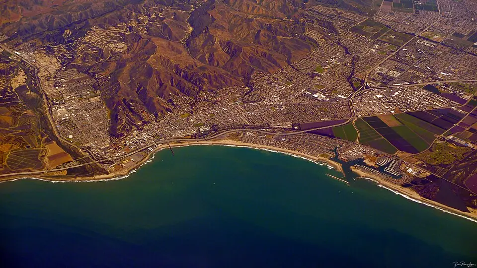
San Buenaventura (Ventura) is a city in Ventura County, California, with 110,763 residents (2020 Census). It sits at 36 ft (11 m) above sea level. The nearest town is North Ventura Avenue, 5.0 miles NW.
- 110,763residents (2020 Census)
- 36 ftelevation · 11 m
- 21.9 sq miland area · 56.6 km²
- 5,064 / sq mipopulation density
- 93003ZIP code
About San Buenaventura (Ventura)
Ventura, officially the City of San Buenaventura (Spanish for "Saint Bonaventure"), is a city in and the county seat of Ventura County, California, United States. It is a coastal city located northwest of Los Angeles. The population was 110,763 at the 2020 United States census. Ventura is a popular tourist destination, owing to its historic landmarks, beaches, and resorts.
Ventura has been inhabited by different peoples, including the Chumash Native Americans, for at least 10,000 years. With the arrival of Spanish missionaries in 1782, Mission San Buenaventura was established by Junípero Serra, giving the city its name. Following the Mexican secularization act of 1833, San Buenaventura was granted by Governor Pío Pico to Don José de Arnaz as Rancho Ex-Mission San Buenaventura and a small community arose. Following the American Conquest of California, San Buenaventura was eventually incorporated as a city in 1866. The 1920s brought a major oil boom which significantly developed and expanded Ventura, a growth that continued with the post–World War II economic expansion.
Text: Wikipedia · CC BY-SA 4.0
San Buenaventura (Ventura) weather: 7-day forecast
Loading the National Weather Service forecast…
Source: National Weather Service (NOAA).
Live webcams in San Buenaventura (Ventura)
All 24 webcams near San Buenaventura (Ventura) ›Things to do in San Buenaventura (Ventura)
Top places to visit in and around San Buenaventura (Ventura): Olivas Adobe, Mullin Automotive Museum and San Buenaventura State Beach.
 Olivas AdobeMuseum · 1.8 mi SE
 Mullin Automotive MuseumMuseum · 7.8 mi SE
 San Buenaventura State BeachBeach · 1.4 mi W
 Emma Wood State BeachBeach · 4.3 mi W
Museums & galleries (9)Historic sites & landmarks (10)Parks & gardens (5)Hiking trails (1)Beaches (7)Scenic viewpoints & peaks (1)Nature reserves & natural wonders (4)Wineries, breweries & distilleries (1)Theaters & public art (4)
All 42 things to do in San Buenaventura (Ventura) ›Living in San Buenaventura (Ventura)
- Median household income
- $103,069
- Median home value
- $827,300
- Median rent
- $2,198/mo
- Median age
- 41.3
Small communities near San Buenaventura (Ventura)
- Pierpont Bay1.0 mi SW
- Ventura2.3 mi W
- Miscanaka2.6 mi W
- Kimballville2.8 mi W
- Chrisman3.4 mi NW
- Kimball3.8 mi E
- Wadstrom3.9 mi NW
- Ortonville4.2 mi NW
- Oxnard Shores5.4 mi S
- West Saticoy5.5 mi E
- Cabrillo Village5.7 mi E
- Weldons5.8 mi NW
- Strickland Acres6.1 mi E
- Foster Park6.5 mi NW
- Dulah6.7 mi NW
- Royal Palms Mobile Home Park subdivision6.9 mi SE
Schools near San Buenaventura (Ventura)
There are no public schools inside San Buenaventura (Ventura). The nearest elementary school is Lemon Grove (0.2 mi S); the nearest middle school is Anacapa Middle (0.5 mi NE); the nearest high school is Pacific High (0.7 mi E).
| School | Grades | Students | Students per teacher | Type | Distance |
|---|---|---|---|---|---|
| Lemon Grove Ventura · Ventura Unified | K–8 | 299 | 21.4 | Public | 0.2 mi S |
| Golden Valley Charter Ventura · Golden Valley Charter District | K–12 | 574 | 31.9 | Charter | 0.5 mi E |
| Anacapa Middle Ventura · Ventura Unified | 6–8 | 592 | 24.7 | Public | 0.5 mi NE |
| Will Rogers Elementary Ventura · Ventura Unified | K–5 | 426 | 28.4 | Public | 0.6 mi NW |
| Pacific High Ventura · Ventura Unified | 9–12 | 213 | 15.2 | Public | 0.7 mi E |
| Loma Vista Elementary Ventura · Ventura Unified | K–5 | 396 | 22.0 | Public | 0.8 mi N |
Do you know San Buenaventura (Ventura)? Tell us about it
Help other travelers: share what makes San Buenaventura (Ventura) special. We review every message before publishing it.
Map of San Buenaventura (Ventura)
Tap any street on the map to see it in Street View below. Map: © OpenStreetMap contributors.
San Buenaventura (Ventura) Street View
Drag the image to look around and tap the arrows on the ground to move. If it says there is no imagery, tap a nearby street on the map above.
Open in Google Maps ›San Buenaventura (Ventura), CA population
San Buenaventura (Ventura) had 110,763 residents in the 2020 Census.
| 2020 Census | 110,763 |
|---|---|
| Density | 5,064 per sq mi (1,955 per km²) |
Source: U.S. Census Bureau, Decennial Census.
San Buenaventura (Ventura) at a glance
| State | California (CA) |
|---|---|
| County | Ventura County |
| Type | City |
| Population | 110,763 (2020) |
| Land area | 21.87 sq mi (56.6 km²) |
| Water area | 10.42 sq mi (26.98 km²) |
| Elevation | 36 ft (11 m) |
| Coordinates | 34.2678° N, 119.2542° W |
| ZIP code | 93003 |
| Official website | cityofventura.ca.gov |
| Census code (GEOID) | 0665042 |
Sources: U.S. Census Bureau (Gazetteer, ZCTA), USGS GNIS, Wikidata.
Towns near San Buenaventura (Ventura)
- North Ventura Avenue5.0 mi NW
- Oxnard5.4 mi SE
- El Rio5.8 mi E
- Saticoy6.4 mi E
- Channel Islands Beach7.0 mi S
- Nyeland Acres7.5 mi E
- Port Hueneme7.8 mi S
- Oak View9.7 mi N
- Mira Monte11.4 mi N
- Santa Paula12.3 mi NE
- Ojai12.5 mi N
- Meiners Oaks13.0 mi N
Straight-line distance between town centers.
Frequently asked questions about San Buenaventura (Ventura)
What county is San Buenaventura (Ventura) in?
San Buenaventura (Ventura) is in Ventura County, California.
What is the population of San Buenaventura (Ventura), CA?
110,763 people lived in San Buenaventura (Ventura) at the 2020 Census.
What is the ZIP code of San Buenaventura (Ventura), CA?
The ZIP code of San Buenaventura (Ventura) is 93003.
What is the elevation of San Buenaventura (Ventura)?
36 feet (11 m) above sea level.
What towns are near San Buenaventura (Ventura)?
North Ventura Avenue (5.0 mi), Oxnard (5.4 mi), El Rio (5.8 mi), Saticoy (6.4 mi), Channel Islands Beach (7.0 mi).
Last updated: