Miranda
Census-designated place in Humboldt County, California
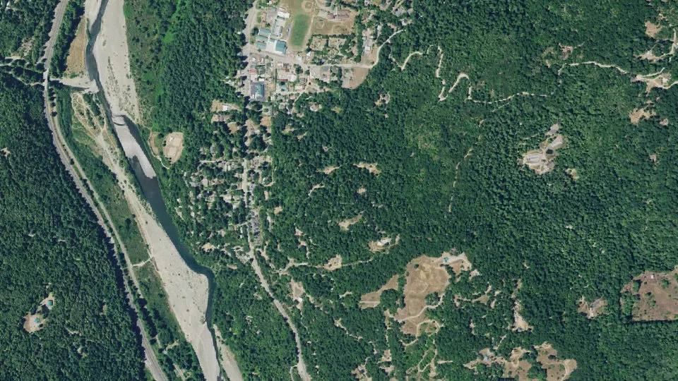
Miranda is an unincorporated community (census-designated place) in Humboldt County, California, with 441 residents (2020 Census). It sits at 351 ft (107 m) above sea level. The nearest town is Phillipsville, 2.5 miles SE.
- 441residents (2020 Census)
- 351 ftelevation · 107 m
- 1.5 sq miland area · 3.9 km²
- 295 / sq mipopulation density
- 95553ZIP code
About Miranda
Miranda (formerly Jacobsen's) is a census-designated place in Humboldt County, California, United States. It is located 2.5 miles (4 km) northwest of Phillipsville, at an elevation of 351 feet (107 m). The ZIP Code is 95553. The population was 441 at the 2020 census.
The name Miranda was originally applied to the area's post office on August 26, 1905. One account states that it is not known whether the name giver had in mind a girl or the well-known Spanish place name and family name. Miranda was known as Jacobsen's Valley until the post office was established. Another account states that Etta Coombs chose the name "Miranda" for the post office she started. Miranda is located on the Avenue of the Giants between Myers Flat to the north and Phillipsville to the south.
South Fork High School is the only regular high school of Southern Humboldt Unified School District, and currently boasts around 150 students from all of southern Humboldt County. The school's name refers to the South Fork of the Eel River. Osprey Learning Center, an alternative continuation high school, is located across the football field from SFHS in facilities that formerly housed Miranda Junior High School. Today, Miranda Junior High School now stands where the former tennis court was, as construction was completed in 2014.
The ZIP Code is 95553. The community is inside area code 707. Elevation is said to be 351 feet at the town sign, though the terrain is generally not flat and encompasses elevations ranging from sea level to over 2,000 feet (610 m). Miranda is in the Pacific Standard Time zone and observes daylight saving time.
Text: Wikipedia · CC BY-SA 4.0
Miranda weather: 7-day forecast
Loading the National Weather Service forecast…
Source: National Weather Service (NOAA).
Live webcams in Miranda
Traffic cameras: Caltrans
Living in Miranda
- Median household income
- $39,390
- Median home value
- $409,100
- Median age
- 24
Do you know Miranda? Tell us about it
Help other travelers: share what makes Miranda special. We review every message before publishing it.
Map of Miranda
Tap any street on the map to see it in Street View below. Map: © OpenStreetMap contributors.
Miranda Street View
Drag the image to look around and tap the arrows on the ground to move. If it says there is no imagery, tap a nearby street on the map above.
Open in Google Maps ›Miranda, CA population
Miranda had 441 residents in the 2020 Census.
| 2020 Census | 441 |
|---|---|
| Density | 295 per sq mi (114 per km²) |
Source: U.S. Census Bureau, Decennial Census.
Miranda at a glance
| State | California (CA) |
|---|---|
| County | Humboldt County |
| Type | Census-designated place |
| Population | 441 (2020) |
| Land area | 1.49 sq mi (3.9 km²) |
| Water area | 0.01 sq mi (0.02 km²) |
| Elevation | 351 ft (107 m) |
| Coordinates | 40.2315° N, 123.8202° W |
| ZIP code | 95553 |
| Census code (GEOID) | 0648060 |
Sources: U.S. Census Bureau (Gazetteer, ZCTA), USGS GNIS, Wikidata.
Towns near Miranda
- Phillipsville2.5 mi SE
- Myers Flat3.7 mi NW
- Redway7.7 mi S
- Weott8.2 mi NW
- Garberville9.2 mi S
- Alderpoint11.8 mi SE
- Benbow12.2 mi S
- Redcrest13.4 mi NW
- Shelter Cove18.2 mi SW
- Mad River22.2 mi NE
- Scotia22.7 mi NW
- Rio Dell24.0 mi NW
Straight-line distance between town centers.
Frequently asked questions about Miranda
What county is Miranda in?
Miranda is in Humboldt County, California.
What is the population of Miranda, CA?
441 people lived in Miranda at the 2020 Census.
What is the ZIP code of Miranda, CA?
The ZIP code of Miranda is 95553.
What is the elevation of Miranda?
351 feet (107 m) above sea level.
What towns are near Miranda?
Phillipsville (2.5 mi), Myers Flat (3.7 mi), Redway (7.7 mi), Weott (8.2 mi), Garberville (9.2 mi).
Last updated: