Emerald Lake Hills
Census-designated place in San Mateo County, California
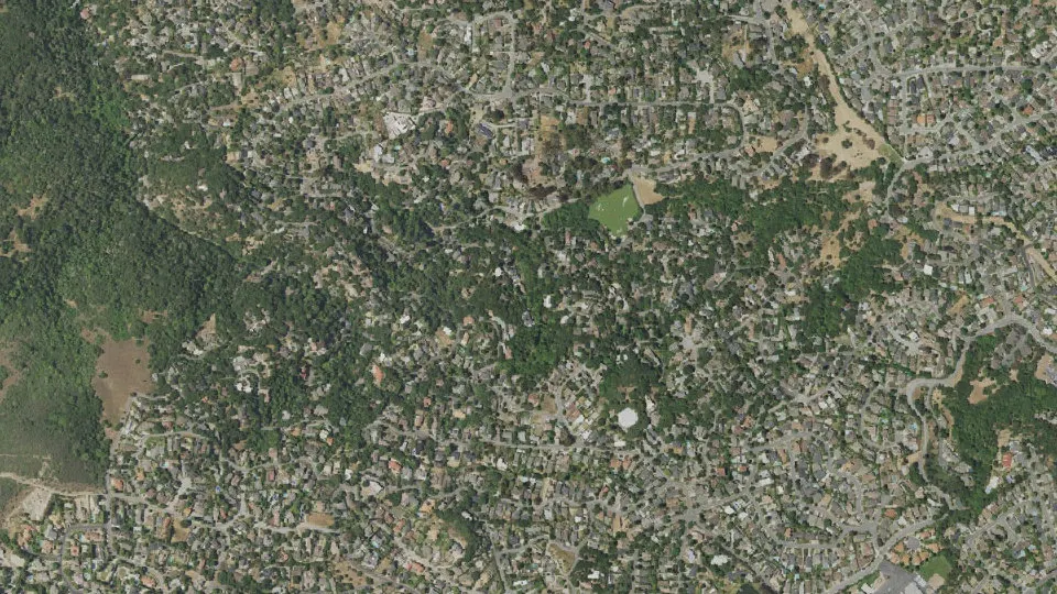
Emerald Lake Hills is an unincorporated community (census-designated place) in San Mateo County, California, with 4,406 residents (2020 Census). It sits at 518 ft (158 m) above sea level. The nearest town is San Carlos, 2.3 miles N.
- 4,406residents (2020 Census)
- 518 ftelevation · 158 m
- 1.2 sq miland area · 3.1 km²
- 3,727 / sq mipopulation density
- 94061ZIP code
About Emerald Lake Hills
Emerald Lake Hills or Emerald Hills is a census-designated place and neighborhood in unincorporated San Mateo County, in the state of California, United States. Situated among oak-studded hills between Woodside, Redwood City, and San Carlos roughly bounded by Edgewood Road, Alameda de las Pulgas, Farm Hill Boulevard, and Interstate 280. The population was 4,406 at the 2020 census and the per-capita income was $68,966, making it the 22nd wealthiest place in California and the 82nd highest income places in the United States
Emerald Lake Hills was originally conceived as a resort community for city-weary San Franciscans during World War I. Emerald Lake Hills actually consists of two large subdivisions created around 1920: Emerald Lake (even though there are two lakes) and Emerald Hills. Residents refer to the area by either Emerald Hills or by Emerald Lake Hills. The name Emerald Hills is now more commonly adopted due to mailing designation rules, as the U.S. Post Office would allow only a two-word name.
According to an interview with Yuji Naka, Emerald Hills is the namesake for the famous Emerald Hill Zone, the first level of Sonic the Hedgehog 2.
Text: Wikipedia · CC BY-SA 4.0
Emerald Lake Hills weather: 7-day forecast
Loading the National Weather Service forecast…
Source: National Weather Service (NOAA).
Live webcams in Emerald Lake Hills
Living in Emerald Lake Hills
- Median household income
- $250,001
- Median home value
- $2,000,001
- Median rent
- $3,501/mo
- Median age
- 45.4
Do you know Emerald Lake Hills? Tell us about it
Help other travelers: share what makes Emerald Lake Hills special. We review every message before publishing it.
Map of Emerald Lake Hills
Tap any street on the map to see it in Street View below. Map: © OpenStreetMap contributors.
Emerald Lake Hills Street View
Drag the image to look around and tap the arrows on the ground to move. If it says there is no imagery, tap a nearby street on the map above.
Open in Google Maps ›Emerald Lake Hills, CA population
Emerald Lake Hills had 4,406 residents in the 2020 Census.
| 2020 Census | 4,406 |
|---|---|
| Density | 3,727 per sq mi (1,439 per km²) |
Source: U.S. Census Bureau, Decennial Census.
Emerald Lake Hills at a glance
| State | California (CA) |
|---|---|
| County | San Mateo County |
| Type | Census-designated place |
| Population | 4,406 (2020) |
| Land area | 1.18 sq mi (3.1 km²) |
| Water area | 0.01 sq mi (0.02 km²) |
| Elevation | 518 ft (158 m) |
| Coordinates | 37.4657° N, 122.2654° W |
| ZIP code | 94061 |
| Census code (GEOID) | 0622587 |
Sources: U.S. Census Bureau (Gazetteer, ZCTA), USGS GNIS, Wikidata.
Towns near Emerald Lake Hills
- San Carlos2.3 mi N
- Woodside3.0 mi S
- North Fair Oaks3.5 mi E
- Atherton3.6 mi E
- Belmont3.7 mi NW
- West Menlo Park4.0 mi SE
- Redwood City4.4 mi NE
- Highlands5.8 mi NW
- Ladera5.8 mi SE
- Stanford6.0 mi SE
- Baywood Park6.1 mi NW
- Menlo Park6.5 mi E
Straight-line distance between town centers.
Frequently asked questions about Emerald Lake Hills
What county is Emerald Lake Hills in?
Emerald Lake Hills is in San Mateo County, California.
What is the population of Emerald Lake Hills, CA?
4,406 people lived in Emerald Lake Hills at the 2020 Census.
What is the ZIP code of Emerald Lake Hills, CA?
The ZIP code of Emerald Lake Hills is 94061.
What is the elevation of Emerald Lake Hills?
518 feet (158 m) above sea level.
What towns are near Emerald Lake Hills?
San Carlos (2.3 mi), Woodside (3.0 mi), North Fair Oaks (3.5 mi), Atherton (3.6 mi), Belmont (3.7 mi).
Last updated: