East Palo Alto
City in San Mateo County, California
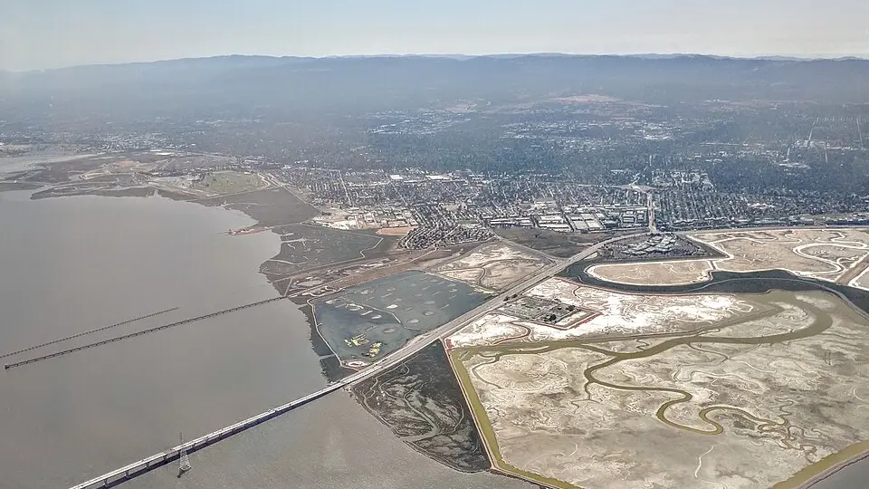
East Palo Alto is a city in San Mateo County, California, with 30,034 residents (2020 Census). It sits at 20 ft (6 m) above sea level. The nearest town is Menlo Park, 1.2 miles NW.
- 30,034residents (2020 Census)
- 20 ftelevation · 6 m
- 2.5 sq miland area · 6.5 km²
- 11,881 / sq mipopulation density
- 94303ZIP code
About East Palo Alto
East Palo Alto ( EAST PAL-oh AL-toh; abbreviated E.P.A.) is a city in San Mateo County, California, United States. As of the 2020 census, the population of East Palo Alto was 30,034. It is situated on the San Francisco Peninsula, roughly halfway between the cities of San Francisco and San Jose. To the north and east is the San Francisco Bay, to the west is the city of Menlo Park, and to the south the city of Palo Alto. East Palo Alto was founded as an unincorporated community and was incorporated in July 1983. The two cities are separated only by San Francisquito Creek and, largely, the Bayshore Freeway (the vast majority of East Palo Alto is northeast of the freeway, while all of the residential part of Palo Alto is southwest of the freeway). The revitalization projects in 2000, and high income high-tech professionals moving into new developments, including employees from Google and Facebook, have begun to slowly eliminate the historically wide cultural and economic differences between the two cities. East Palo Alto and Palo Alto share both telephone area codes and postal ZIP codes.
In 1990, 43% of East Palo Alto's residents were African Americans, which was the result of redlining practices and racial deed restrictions in Palo Alto, while 34% were Latinos. As of 2020, African Americans were 11%, while Latinos are about 66%. A small minority of Pacific Islanders also reside in East Palo Alto, most of Tongan, Samoan, and Fijian origin.
The prosperity that benefited Silicon Valley during the dot-com boom of the late 1990s largely bypassed East Palo Alto. The Ravenswood City School District, which serves East Palo Alto and part of adjoining Menlo Park, has struggled with low academic performance. Eventually, however, the Peninsula's shortage of land and soaring property prices meant that East Palo Alto became an option for urban regeneration.
East Palo Alto includes a small piece of land southwest of the Bayshore Freeway (U.S. Route 101), across the freeway from the Gateway 101 shopping center. This land is roughly triangular and sits between the freeway and San Francisquito Creek. This land was formerly the site of a two-block-long retail business district known as Whiskey Gulch. Since 1888, Stanford University, on the west side of Palo Alto, prohibited alcohol sales within a radius of 1.5-mile (2.4 km) from the campus. Whiskey Gulch, which was just outside these limits, became home to a number of liquor stores, bars, and music venues. The rules were relaxed in 1970, but the neighborhood still retained this character until 2000, when the city tore down Whiskey Gulch and replaced it with the University Circle office complex. A 200-room Four Seasons hotel opened in University Circle in 2006.
Over 25% of East Palo Alto (400+ acres) has been bulldozed and replaced with brand new housing and brand-name retail establishments since approximately 1997, attracting an entirely new demographic. The University Square community has become particularly appealing to young high-tech professionals and high-income couples, including many employees from Google, Facebook, Sun Microsystems, Yahoo!, and various other software and startup companies.
Text: Wikipedia · CC BY-SA 4.0
East Palo Alto weather: 7-day forecast
Loading the National Weather Service forecast…
Source: National Weather Service (NOAA).
Live webcams in East Palo Alto
All 24 webcams near East Palo Alto ›Living in East Palo Alto
- Median household income
- $113,493
- Median home value
- $1,102,600
- Median rent
- $2,244/mo
- Median age
- 36.3
Small communities near East Palo Alto
- Runnymeade0.1 mi W
- Ravenswood0.6 mi N
- Ravenswood0.6 mi N
- Menlo Oaks1.9 mi W
- Escondido Village3.1 mi S
- Trailer Rancho Mobile Home Park3.4 mi W
- Raines Houses3.5 mi SW
- Raines Houses3.5 mi SW
- Trailer Villa Mobile Home Park subdivision3.6 mi W
- Pierce Mitchell Houses3.7 mi SW
- Neal3.8 mi S
- Sequoia Mobile Home Park subdivision3.9 mi W
- Sequoia Mobile Home Park subdivision3.9 mi W
- Redwood Mobile Home Park subdivision4.0 mi W
- Redwood Trailer Village subdivision4.0 mi W
- Le Mar Mobile Home Park subdivision4.2 mi W
Do you know East Palo Alto? Tell us about it
Help other travelers: share what makes East Palo Alto special. We review every message before publishing it.
Map of East Palo Alto
Tap any street on the map to see it in Street View below. Map: © OpenStreetMap contributors.
East Palo Alto Street View
Drag the image to look around and tap the arrows on the ground to move. If it says there is no imagery, tap a nearby street on the map above.
Open in Google Maps ›East Palo Alto, CA population
East Palo Alto had 30,034 residents in the 2020 Census.
| 2020 Census | 30,034 |
|---|---|
| Density | 11,881 per sq mi (4,587 per km²) |
Source: U.S. Census Bureau, Decennial Census.
East Palo Alto at a glance
| State | California (CA) |
|---|---|
| County | San Mateo County |
| Type | City |
| Population | 30,034 (2020) |
| Land area | 2.53 sq mi (6.5 km²) |
| Water area | 0.12 sq mi (0.30 km²) |
| Elevation | 20 ft (6 m) |
| Coordinates | 37.4678° N, 122.1326° W |
| ZIP code | 94303 |
| Official website | cityofepa.org |
| Census code (GEOID) | 0620956 |
Sources: U.S. Census Bureau (Gazetteer, ZCTA), USGS GNIS, Wikidata.
Towns near East Palo Alto
- Menlo Park1.2 mi NW
- Stanford3.4 mi SW
- Atherton3.9 mi W
- North Fair Oaks3.9 mi W
- West Menlo Park4.5 mi SW
- Palo Alto5.0 mi S
- Redwood City5.5 mi NW
- Mountain View5.5 mi SE
- Ladera5.9 mi SW
- Newark6.0 mi NE
- Los Altos Hills7.0 mi S
- Los Altos7.1 mi S
Straight-line distance between town centers.
Frequently asked questions about East Palo Alto
What county is East Palo Alto in?
East Palo Alto is in San Mateo County, California.
What is the population of East Palo Alto, CA?
30,034 people lived in East Palo Alto at the 2020 Census.
What is the ZIP code of East Palo Alto, CA?
The ZIP code of East Palo Alto is 94303.
What is the elevation of East Palo Alto?
20 feet (6 m) above sea level.
What towns are near East Palo Alto?
Menlo Park (1.2 mi), Stanford (3.4 mi), Atherton (3.9 mi), North Fair Oaks (3.9 mi), West Menlo Park (4.5 mi).
Last updated: