Absarokee
Census-designated place in Stillwater County, Montana
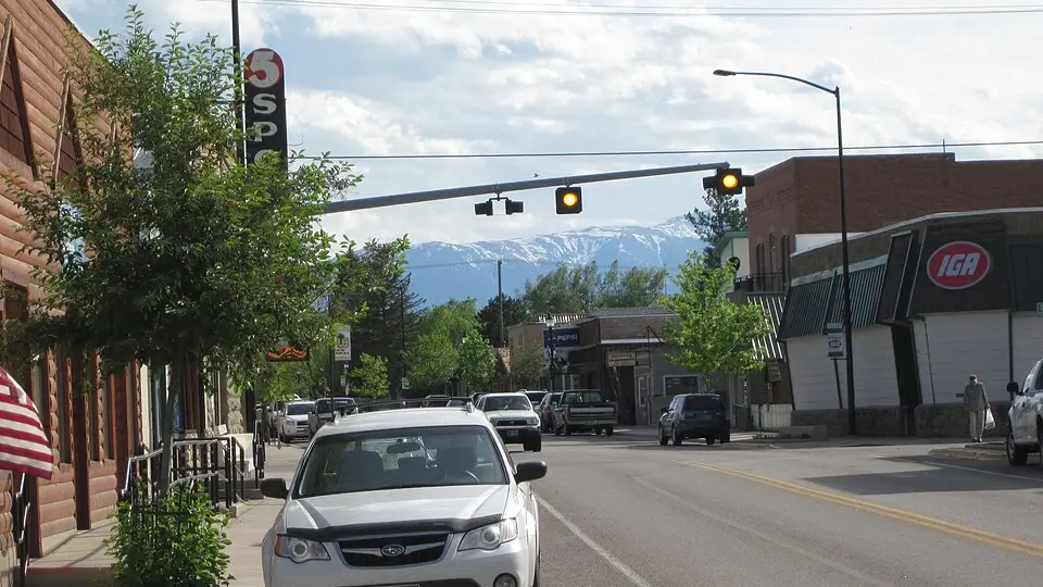
Absarokee is an unincorporated community (census-designated place) in Stillwater County, Montana, with 1,000 residents (2020 Census). It sits at 4,039 ft (1,231 m) above sea level. The nearest town is Fishtail, 6.1 miles SW.
- 1,000residents (2020 Census)
- 4,039 ftelevation · 1,231 m
- 2.1 sq miland area · 5.5 km²
- 467 / sq mipopulation density
- 59001ZIP code
About Absarokee
Absarokee is a census-designated place (CDP) in Stillwater County, Montana, United States, approximately 14 miles (23 km) south of Columbus on Highway 78. It is named after the Crow Indians who formerly inhabited the land. The population was 1,000 at the 2020 census. The Stillwater Mine, operated by the Stillwater Mining Company, is located near Absarokee.
Text: Wikipedia · CC BY-SA 4.0
Absarokee weather: 7-day forecast
Loading the National Weather Service forecast…
Source: National Weather Service (NOAA).
Live webcams in Absarokee
Webcams: Windy.com
Things to do in Absarokee
Top places to visit in and around Absarokee: Cooney State Park, Oliver H. Hovda House and Greycliff Prairie Dog Town State Park.
 Oliver H. Hovda HouseHistoric house · in town
 Greycliff Prairie Dog Town State ParkState park · 23 mi NW
 Halfway HouseHistoric house · 6.6 mi NE
Historic sites & landmarks (10)Parks & gardens (2)Scenic viewpoints & peaks (10)Nature reserves & natural wonders (10)Theaters & public art (1)Golf, marinas & outdoor sports (1)
All 34 things to do in Absarokee ›Living in Absarokee
- Median household income
- $77,143
- Median home value
- $292,000
- Median rent
- $927/mo
- Median age
- 42.3
Schools in Absarokee
Absarokee has 3 public schools. The elementary school is Absarokee School; the middle school is Absarokee 6-8; the high school is Absarokee High School.
| School | Grades | Students | Students per teacher | Type | Distance |
|---|---|---|---|---|---|
| Absarokee School Absarokee · Absarokee Elem | PK–5 | 79 | 11.3 | Public | 1.0 mi SE |
| Absarokee 6-8 Absarokee · Absarokee Elem | 6–8 | 41 | 10.3 | Public | 1.0 mi SE |
| Absarokee High School Absarokee · Absarokee H S | 9–12 | 74 | 9.3 | Public | 1.0 mi SE |
| Fishtail School Fishtail · Fishtail Elem | PK–8 | 15 | 15.0 | Public | 5.7 mi SW |
| Columbus Elem School Columbus · Columbus Elem | PK–5 | 278 | 15.4 | Public | 12 mi NE |
| Columbus Middle School Columbus · Columbus Elem | 6–8 | 178 | 19.8 | Public | 13 mi NE |
Do you know Absarokee? Tell us about it
Help other travelers: share what makes Absarokee special. We review every message before publishing it.
Map of Absarokee
Tap any street on the map to see it in Street View below. Map: © OpenStreetMap contributors.
Absarokee Street View
Drag the image to look around and tap the arrows on the ground to move. If it says there is no imagery, tap a nearby street on the map above.
Open in Google Maps ›Absarokee, MT population
Absarokee had 1,000 residents in the 2020 Census.
| 2020 Census | 1,000 |
|---|---|
| Density | 467 per sq mi (180 per km²) |
Source: U.S. Census Bureau, Decennial Census.
Absarokee at a glance
| State | Montana (MT) |
|---|---|
| County | Stillwater County |
| Type | Census-designated place |
| Population | 1,000 (2020) |
| Land area | 2.14 sq mi (5.5 km²) |
| Water area | 0.01 sq mi (0.02 km²) |
| Elevation | 4,039 ft (1,231 m) |
| Coordinates | 45.5276° N, 109.4558° W |
| ZIP code | 59001 |
| Census code (GEOID) | 3000175 |
Sources: U.S. Census Bureau (Gazetteer, ZCTA), USGS GNIS, Wikidata.
Towns near Absarokee
- Fishtail6.1 mi SW
- Roscoe12.3 mi S
- Columbus12.5 mi NE
- Reed Point13.2 mi N
- Luther16.9 mi S
- Nye18.2 mi W
- Roberts18.4 mi SE
- Boyd19.4 mi E
- Fox20.3 mi SE
- Greycliff22.4 mi NW
- Joliet23.6 mi E
- Red Lodge25.2 mi SE
Straight-line distance between town centers.
Frequently asked questions about Absarokee
What county is Absarokee in?
Absarokee is in Stillwater County, Montana.
What is the population of Absarokee, MT?
1,000 people lived in Absarokee at the 2020 Census.
What is the ZIP code of Absarokee, MT?
The ZIP code of Absarokee is 59001.
What is the elevation of Absarokee?
4,039 feet (1,231 m) above sea level.
What towns are near Absarokee?
Fishtail (6.1 mi), Roscoe (12.3 mi), Columbus (12.5 mi), Reed Point (13.2 mi), Luther (16.9 mi).
Last updated: